

Gościejów
A cycling route starting in Pogwizdów, Silesian Voivodeship, Poland.
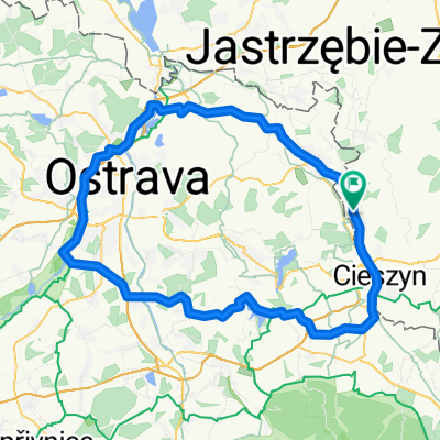
Overview
About this route
Wyjazd ze Ślepej Dobki na Trzy Kopce Wiślańskie i dalej na Gościejów. Fajny zjazd leśna przecinką do Brennej Leśnicy
- -:--
- Duration
- 78.6 km
- Distance
- 661 m
- Ascent
- 661 m
- Descent
- ---
- Avg. speed
- ---
- Max. altitude

Route quality
Waytypes & surfaces along the route
Waytypes
Road
41.3 km
(53 %)
Quiet road
16 km
(20 %)
Surfaces
Paved
37.7 km
(48 %)
Unpaved
3.3 km
(4 %)
Asphalt
36.8 km
(47 %)
Ground
2 km
(3 %)
Route highlights
Points of interest along the route

Point of interest after 29.4 km
Wisła w Ustroniu Polanie

Point of interest after 34.7 km
Ślepa Dobka - poczatek podjazdu

Point of interest after 35.5 km
w lesie

Point of interest after 36.7 km
na niebieskim szlaku

Point of interest after 37.6 km
Trzy Kopce Wiślańskie

Point of interest after 37.6 km
Trzy Kopce Wiślańskie - Bufet Telesforówka

Point of interest after 39 km
Gościejów

Point of interest after 39 km
Zjazd z Gościejowa

Point of interest after 39.4 km

Point of interest after 39.4 km
to było super

Point of interest after 39.7 km
U Gazdy

Point of interest after 39.9 km
coś dla odważnych

Point of interest after 40.7 km
ostatni etap zjazdu

Point of interest after 52 km
Chlebowa Chata

Point of interest after 54.6 km
Brennica
Continue with Bikemap
Use, edit, or download this cycling route
You would like to ride Gościejów or customize it for your own trip? Here is what you can do with this Bikemap route:
Free features
- Save this route as favorite or in collections
- Copy & plan your own version of this route
- Sync your route with Garmin or Wahoo
Premium features
Free trial for 3 days, or one-time payment. More about Bikemap Premium.
- Navigate this route on iOS & Android
- Export a GPX / KML file of this route
- Create your custom printout (try it for free)
- Download this route for offline navigation
Discover more Premium features.
Get Bikemap PremiumFrom our community
Other popular routes starting in Pogwizdów
 Pszczyna
- Distance
- 99.6 km
- Ascent
- 265 m
- Descent
- 265 m
- Location
- Pogwizdów, Silesian Voivodeship, Poland
 Nad Odrę
- Distance
- 102.5 km
- Ascent
- 326 m
- Descent
- 328 m
- Location
- Pogwizdów, Silesian Voivodeship, Poland
 Wokół Cieszyna
- Distance
- 42.9 km
- Ascent
- 494 m
- Descent
- 491 m
- Location
- Pogwizdów, Silesian Voivodeship, Poland
 Zimowy Kaczok
- Distance
- 9.6 km
- Ascent
- 76 m
- Descent
- 73 m
- Location
- Pogwizdów, Silesian Voivodeship, Poland
 Pogwizdów - Lobau - FORCHTENSTEIN - Heidenturm - Pogwizdów
- Distance
- 1,039.7 km
- Ascent
- 6,341 m
- Descent
- 6,280 m
- Location
- Pogwizdów, Silesian Voivodeship, Poland
 Do i z pracy, wersja okrężna ;)
- Distance
- 67.5 km
- Ascent
- 456 m
- Descent
- 456 m
- Location
- Pogwizdów, Silesian Voivodeship, Poland
 Szyndzielnia i Klimczok późną jesienią
- Distance
- 98.4 km
- Ascent
- 1,011 m
- Descent
- 1,011 m
- Location
- Pogwizdów, Silesian Voivodeship, Poland
 Gościejów
- Distance
- 78.6 km
- Ascent
- 661 m
- Descent
- 661 m
- Location
- Pogwizdów, Silesian Voivodeship, Poland
Open it in the app