

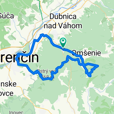
Trenčianské Teplice - Lúčky - Chata pod Ostrým vrchom - Soblahov
A cycling route starting in Trenčianske Teplice, Nitriansky kraj, Slovak Republic.
Overview
About this route
15,28 km dlhá trasa z Trenčianských Teplíc po hrebeni Trenčianskej vrchoviny cez Lúčky a pod Ostrý vrch ku chate pod Ostrým vrchom a od tiaľ do Soblahova.
- -:--
- Duration
- 15.3 km
- Distance
- 603 m
- Ascent
- 598 m
- Descent
- ---
- Avg. speed
- ---
- Max. altitude

Route quality
Waytypes & surfaces along the route
Waytypes
Track
11.9 km
(77 %)
Busy road
1.4 km
(9 %)
Surfaces
Paved
2.3 km
(15 %)
Unpaved
10 km
(65 %)
Unpaved (undefined)
4.9 km
(32 %)
Ground
4.3 km
(28 %)
Continue with Bikemap
Use, edit, or download this cycling route
You would like to ride Trenčianské Teplice - Lúčky - Chata pod Ostrým vrchom - Soblahov or customize it for your own trip? Here is what you can do with this Bikemap route:
Free features
- Save this route as favorite or in collections
- Copy & plan your own version of this route
- Sync your route with Garmin or Wahoo
Premium features
Free trial for 3 days, or one-time payment. More about Bikemap Premium.
- Navigate this route on iOS & Android
- Export a GPX / KML file of this route
- Create your custom printout (try it for free)
- Download this route for offline navigation
Discover more Premium features.
Get Bikemap PremiumFrom our community
Other popular routes starting in Trenčianske Teplice
 17. novembra 37 do 17. novembra 290
- Distance
- 35.1 km
- Ascent
- 372 m
- Descent
- 441 m
- Location
- Trenčianske Teplice, Nitriansky kraj, Slovak Republic
 Omšenie - Omšenská Baba - Omšenie
- Distance
- 4.4 km
- Ascent
- 323 m
- Descent
- 321 m
- Location
- Trenčianske Teplice, Nitriansky kraj, Slovak Republic
 Tren. Teplice-TN-Lucky-Machnac-Baske-Tren. Teplice
- Distance
- 52.3 km
- Ascent
- 1,080 m
- Descent
- 1,080 m
- Location
- Trenčianske Teplice, Nitriansky kraj, Slovak Republic
 Trenč.Teplice-Trenč.Teplá - Nemšová
- Distance
- 11.2 km
- Ascent
- 13 m
- Descent
- 57 m
- Location
- Trenčianske Teplice, Nitriansky kraj, Slovak Republic
 Trenčianske Teplice - Motešice - Bobot
- Distance
- 13 km
- Ascent
- 203 m
- Descent
- 239 m
- Location
- Trenčianske Teplice, Nitriansky kraj, Slovak Republic
 Homôlka-Zliechov-Mojtín-Košecké Podhradie-Iliavka-Dubnica.
- Distance
- 51.6 km
- Ascent
- 1,770 m
- Descent
- 2,164 m
- Location
- Trenčianske Teplice, Nitriansky kraj, Slovak Republic
 Kúpeľný duatlon Trenčianske Teplice
- Distance
- 20 km
- Ascent
- 371 m
- Descent
- 372 m
- Location
- Trenčianske Teplice, Nitriansky kraj, Slovak Republic
 TN MTB #1
- Distance
- 52.8 km
- Ascent
- 1,091 m
- Descent
- 1,091 m
- Location
- Trenčianske Teplice, Nitriansky kraj, Slovak Republic
Open it in the app