

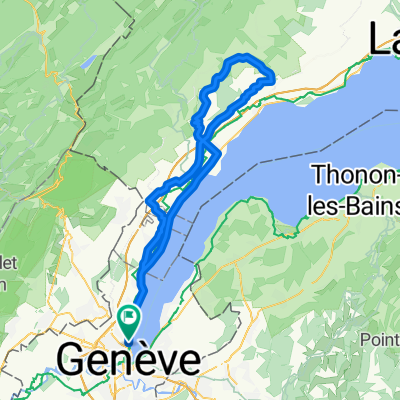
signal de bougy
A cycling route starting in Le Grand-Saconnex, Canton of Geneva, Switzerland.
Overview
About this route
plat et valloné par moment
- -:--
- Duration
- 85.6 km
- Distance
- 577 m
- Ascent
- 576 m
- Descent
- ---
- Avg. speed
- ---
- Max. altitude
Route quality
Waytypes & surfaces along the route
Waytypes
Busy road
34.6 km
(40 %)
Road
22 km
(26 %)
Surfaces
Paved
46.7 km
(55 %)
Unpaved
0 km
(<1 %)
Asphalt
43 km
(50 %)
Concrete
3.7 km
(4 %)
Continue with Bikemap
Use, edit, or download this cycling route
You would like to ride signal de bougy or customize it for your own trip? Here is what you can do with this Bikemap route:
Free features
- Save this route as favorite or in collections
- Copy & plan your own version of this route
- Split it into stages to create a multi-day tour
- Sync your route with Garmin or Wahoo
Premium features
Free trial for 3 days, or one-time payment. More about Bikemap Premium.
- Navigate this route on iOS & Android
- Export a GPX / KML file of this route
- Create your custom printout (try it for free)
- Download this route for offline navigation
Discover more Premium features.
Get Bikemap PremiumFrom our community
Other popular routes starting in Le Grand-Saconnex
 Geneva Lake Cycling Test Run
- Distance
- 90.5 km
- Ascent
- 164 m
- Descent
- 197 m
- Location
- Le Grand-Saconnex, Canton of Geneva, Switzerland
 G2N D1 Base route
- Distance
- 93.7 km
- Ascent
- 981 m
- Descent
- 1,087 m
- Location
- Le Grand-Saconnex, Canton of Geneva, Switzerland
 Petit Saconnex - Bellevue
- Distance
- 17.2 km
- Ascent
- 142 m
- Descent
- 144 m
- Location
- Le Grand-Saconnex, Canton of Geneva, Switzerland
 Tour de Saleve
- Distance
- 70.5 km
- Ascent
- 1,286 m
- Descent
- 1,287 m
- Location
- Le Grand-Saconnex, Canton of Geneva, Switzerland
 Contreforts du Jura
- Distance
- 51.8 km
- Ascent
- 729 m
- Descent
- 734 m
- Location
- Le Grand-Saconnex, Canton of Geneva, Switzerland
 Col du Marchairuz (Road)
- Distance
- 106.6 km
- Ascent
- 1,560 m
- Descent
- 1,533 m
- Location
- Le Grand-Saconnex, Canton of Geneva, Switzerland
 Vesancy to OMS via Mourex
- Distance
- 16.9 km
- Ascent
- 350 m
- Descent
- 145 m
- Location
- Le Grand-Saconnex, Canton of Geneva, Switzerland
 signal de bougy
- Distance
- 85.6 km
- Ascent
- 577 m
- Descent
- 576 m
- Location
- Le Grand-Saconnex, Canton of Geneva, Switzerland
Open it in the app