Pauliberg, Römerstrasse, bauregger
- 6.3 km
- 180 m
- 242 m
- Bad Schallerbach, Upper Austria, Austria
A cycling route starting in Bad Schallerbach, Upper Austria, Austria.
Overview
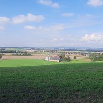
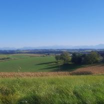
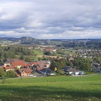
Scenically, this perfect road cycling route offers a lot. From Neukirchen im Walde back to St. Aegidi and then down a beautiful descent to Engelhartszell is the first section of the route. The climbs are, as on the whole route, very moderate and almost invite you to push harder. However, you shouldn’t, because the area is simply too beautiful. After crossing the Danube just before Wesenufer, you go up a road located in the forest towards Hofkirchen im Mühlkreis. Along the way, you can also enjoy a view of the Danube. The slightly less pleasant part due to traffic is from the roundabout in Freileben to the roundabout / junction to St. Martin just before Dunzendorf. Once you pass St. Martin and swallow 2-3 hills, it’s a fast descent down to Aschach, where some cafes invite you to relax. Well-rested, you can then tackle the remaining 40 km that still lead over the Scharten. After exactly 145 km (actually it’s almost 2000 m of elevation gain), the goal is reached again.
created this 11 years ago
Route quality
Quiet road
36.6 km
(26 %)
Road
12.7 km
(9 %)
Paved
56.4 km
(40 %)
Asphalt
56.4 km
(40 %)
Undefined
84.5 km
(60 %)
Continue with Bikemap
You would like to ride 140km Pichl - Wesenufer - St. Martin - Scharten - Pichl or customize it for your own trip? Here is what you can do with this Bikemap route:
Free trial for 3 days, or one-time payment. More about Bikemap Premium.
Discover more Premium features.
Get Bikemap PremiumFrom our community
Open it in the app