

Die "Haschemer" West Route
A cycling route starting in Einselthum, Rhineland-Palatinate, Germany.
Overview
About this route
leider sind manche Wege im Plan nicht korrekt eingetragen. Hier ein paar konkrete Wegpunkte:
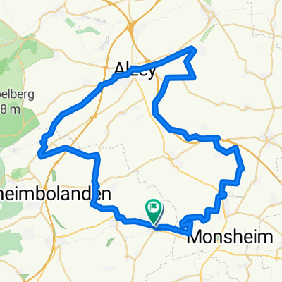
In Harxheim am Friedhof vorbei nach Albisheim, dann dem Verlauf der Pfrimm folgen. In Albisheim bis zur "Unteren Bahnstraße", ca. 150m bis zum Bahnübergang dann rechts auf Schotterweg. Immer dem Verlauf der Pfrimm folgen bis kurz vor Marnheim, dann über kleine Pfrimmbrücke und weiter der Pfrimm in Richtung Dreisen folgen. Bei Froschauerhof abbiegen weiter über die Bahnbrücke bis hoch zur L449. Der Landesstraße bis Elbisheimerhof folgen und dort am Friedhof dem Betonplattenweg folgen in Richtung Steinbruch Rüssinen. Man kommt im Bereich der Betriebsstraße der Dyckerhoff raus. Am Sportheim in Rüssingen (sofern offen) kann man fein lecker ´en Bierchen schlabbern. Dann weiter durch Rüssingen in Richtung Ottersheim und an der Landesstraße L448 wieder zurück über Bubenheim nach Harxheim. Sind ca. 20km und pille-palle-Steigungen!!
Viel Spaß Ulrich Wetzel
- -:--
- Duration
- 20.1 km
- Distance
- 174 m
- Ascent
- 171 m
- Descent
- ---
- Avg. speed
- ---
- Max. altitude
Continue with Bikemap
Use, edit, or download this cycling route
You would like to ride Die "Haschemer" West Route or customize it for your own trip? Here is what you can do with this Bikemap route:
Free features
- Save this route as favorite or in collections
- Copy & plan your own version of this route
- Sync your route with Garmin or Wahoo
Premium features
Free trial for 3 days, or one-time payment. More about Bikemap Premium.
- Navigate this route on iOS & Android
- Export a GPX / KML file of this route
- Create your custom printout (try it for free)
- Download this route for offline navigation
Discover more Premium features.
Get Bikemap PremiumFrom our community
Other popular routes starting in Einselthum
 Route Zellertal-Lambsheim Weiher
- Distance
- 24 km
- Ascent
- 70 m
- Descent
- 140 m
- Location
- Einselthum, Rhineland-Palatinate, Germany
 nach Zell
- Distance
- 0.8 km
- Ascent
- 49 m
- Descent
- 0 m
- Location
- Einselthum, Rhineland-Palatinate, Germany
 Route in Zellertal
- Distance
- 61.1 km
- Ascent
- 594 m
- Descent
- 594 m
- Location
- Einselthum, Rhineland-Palatinate, Germany
 Hauptstraße 7, Zellertal nach Vorstadt 21, Kirchheimbolanden
- Distance
- 15.9 km
- Ascent
- 444 m
- Descent
- 351 m
- Location
- Einselthum, Rhineland-Palatinate, Germany
 Verbindungsweg Zellertal-Barbarossa Wege
- Distance
- 18.6 km
- Ascent
- 316 m
- Descent
- 250 m
- Location
- Einselthum, Rhineland-Palatinate, Germany
 nach Zell
- Distance
- 0.7 km
- Ascent
- 40 m
- Descent
- 0 m
- Location
- Einselthum, Rhineland-Palatinate, Germany
 Zellertalrundfahrt
- Distance
- 24.1 km
- Ascent
- 258 m
- Descent
- 258 m
- Location
- Einselthum, Rhineland-Palatinate, Germany
 Die "Haschemer" West Route
- Distance
- 20.1 km
- Ascent
- 174 m
- Descent
- 171 m
- Location
- Einselthum, Rhineland-Palatinate, Germany
Open it in the app