
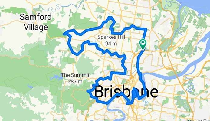
Magical mystery tour- North Side 80km
A cycling route starting in Wooloowin, Queensland, Australia.
Overview
About this route
Mix of varoius trails and road combing some of the ebst from the north side
- -:--
- Duration
- 80.1 km
- Distance
- 324 m
- Ascent
- 328 m
- Descent
- ---
- Avg. speed
- ---
- Max. altitude
Route highlights
Points of interest along the route
Point of interest after 28.7 km
Coffee #1
Point of interest after 58.3 km
Coffee
Continue with Bikemap
Use, edit, or download this cycling route
You would like to ride Magical mystery tour- North Side 80km or customize it for your own trip? Here is what you can do with this Bikemap route:
Free features
- Save this route as favorite or in collections
- Copy & plan your own version of this route
- Split it into stages to create a multi-day tour
- Sync your route with Garmin or Wahoo
Premium features
Free trial for 3 days, or one-time payment. More about Bikemap Premium.
- Navigate this route on iOS & Android
- Export a GPX / KML file of this route
- Create your custom printout (try it for free)
- Download this route for offline navigation
Discover more Premium features.
Get Bikemap PremiumFrom our community
Other popular routes starting in Wooloowin
 Roma-Southbank-Bulimba-Ferry loop
- Distance
- 28.6 km
- Ascent
- 175 m
- Descent
- 181 m
- Location
- Wooloowin, Queensland, Australia
 Eight bridges ride CLONED FROM ROUTE 448741
- Distance
- 81.9 km
- Ascent
- 276 m
- Descent
- 273 m
- Location
- Wooloowin, Queensland, Australia
 Kedron Bk, Settlement Rd, Ennogera Ck
- Distance
- 38 km
- Ascent
- 209 m
- Descent
- 206 m
- Location
- Wooloowin, Queensland, Australia
 Lower Brisbane River loop
- Distance
- 40.9 km
- Ascent
- 180 m
- Descent
- 182 m
- Location
- Wooloowin, Queensland, Australia
 Centenary Bridge, Edenbrook, UQ
- Distance
- 70.2 km
- Ascent
- 248 m
- Descent
- 248 m
- Location
- Wooloowin, Queensland, Australia
 Magical mystery tour- North Side 80km
- Distance
- 80.3 km
- Ascent
- 346 m
- Descent
- 347 m
- Location
- Wooloowin, Queensland, Australia
 Toohey Forest (City, Tarragindi, Norman Creek)
- Distance
- 46 km
- Ascent
- 270 m
- Descent
- 270 m
- Location
- Wooloowin, Queensland, Australia
 Settlement Road (Kedron + Enoggera Creeks)
- Distance
- 42.5 km
- Ascent
- 312 m
- Descent
- 308 m
- Location
- Wooloowin, Queensland, Australia
Open it in the app