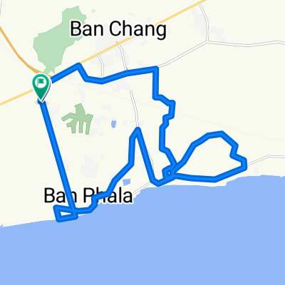
4 June 2014
A cycling route starting in Ban Chang, Changwat Rayong, Thailand.
Overview
About this route
Route is fairly flat and a good ride for training awith a group. Ride can be easily altered to eas or decrease the distance.
- -:--
- Duration
- 92 km
- Distance
- 339 m
- Ascent
- 341 m
- Descent
- ---
- Avg. speed
- ---
- Max. altitude
Continue with Bikemap
Use, edit, or download this cycling route
You would like to ride 4 June 2014 or customize it for your own trip? Here is what you can do with this Bikemap route:
Free features
- Save this route as favorite or in collections
- Copy & plan your own version of this route
- Split it into stages to create a multi-day tour
- Sync your route with Garmin or Wahoo
Premium features
Free trial for 3 days, or one-time payment. More about Bikemap Premium.
- Navigate this route on iOS & Android
- Export a GPX / KML file of this route
- Create your custom printout (try it for free)
- Download this route for offline navigation
Discover more Premium features.
Get Bikemap PremiumFrom our community
Other popular routes starting in Ban Chang
- MTS's Samersan Fish Market and Fishing Village Route
- Distance
- 40.8 km
- Ascent
- 150 m
- Descent
- 158 m
- Location
- Ban Chang, Changwat Rayong, Thailand
- TH_Phala Beach - Chantaburi
- Distance
- 153.7 km
- Ascent
- 109 m
- Descent
- 113 m
- Location
- Ban Chang, Changwat Rayong, Thailand
- Michael's Ban Chang, Klaeng, Wang Chon Route
- Distance
- 240.4 km
- Ascent
- 376 m
- Descent
- 388 m
- Location
- Ban Chang, Changwat Rayong, Thailand
- Na Chom Thian, Sattahip to ชบ. 1003, Sattahip
- Distance
- 12.4 km
- Ascent
- 182 m
- Descent
- 180 m
- Location
- Ban Chang, Changwat Rayong, Thailand
- วัดเส้นทางใหม่
- Distance
- 42.5 km
- Ascent
- 185 m
- Descent
- 225 m
- Location
- Ban Chang, Changwat Rayong, Thailand
- 4 June 2014
- Distance
- 92 km
- Ascent
- 339 m
- Descent
- 341 m
- Location
- Ban Chang, Changwat Rayong, Thailand
- ชบ. 1003, Amphoe Sattahip to ชบ. 1003, Amphoe Sattahip
- Distance
- 17.4 km
- Ascent
- 377 m
- Descent
- 381 m
- Location
- Ban Chang, Changwat Rayong, Thailand
- Ban Chang-Plutaluang-Silver Lake-332-Ban Chang
- Distance
- 54.9 km
- Ascent
- 256 m
- Descent
- 253 m
- Location
- Ban Chang, Changwat Rayong, Thailand
Open it in the app