

Swistbach Tälerroute
A cycling route starting in Meckenheim, North Rhine-Westphalia, Germany.
Overview
About this route
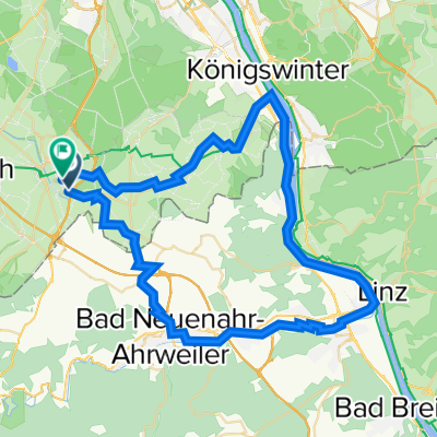
der Swistbach, auch „Swistbach Tälerrute“ genannt, mit der reizvollen Natur, den historischen Ortschaften dürch die Kottenforst-Ville. Zahlreiche Schlösser, Burgen, Museen und die Nähe zum Nationalpark machen den insgesamt etwa 60 Kilometer langen Swistbach-Radweg.
- -:--
- Duration
- 59.8 km
- Distance
- 106 m
- Ascent
- 214 m
- Descent
- ---
- Avg. speed
- ---
- Avg. speed

Continue with Bikemap
Use, edit, or download this cycling route
You would like to ride Swistbach Tälerroute or customize it for your own trip? Here is what you can do with this Bikemap route:
Free features
- Save this route as favorite or in collections
- Copy & plan your own version of this route
- Sync your route with Garmin or Wahoo
Premium features
Free trial for 3 days, or one-time payment. More about Bikemap Premium.
- Navigate this route on iOS & Android
- Export a GPX / KML file of this route
- Create your custom printout (try it for free)
- Download this route for offline navigation
Discover more Premium features.
Get Bikemap PremiumFrom our community
Other popular routes starting in Meckenheim
 Am Rebstock 11, Meckenheim nach Am Rebstock 22, Meckenheim
- Distance
- 14.2 km
- Ascent
- 86 m
- Descent
- 95 m
- Location
- Meckenheim, North Rhine-Westphalia, Germany
 Rund um Rheinbach, Ahr und Eifel
- Distance
- 62.6 km
- Ascent
- 440 m
- Descent
- 440 m
- Location
- Meckenheim, North Rhine-Westphalia, Germany
 Kleine Kottenforst Runde
- Distance
- 25.5 km
- Ascent
- 99 m
- Descent
- 96 m
- Location
- Meckenheim, North Rhine-Westphalia, Germany
 Small round south of Bonn, Germany
- Distance
- 58.4 km
- Ascent
- 300 m
- Descent
- 290 m
- Location
- Meckenheim, North Rhine-Westphalia, Germany
 vom Kottenforst zum Königsforst
- Distance
- 64.6 km
- Ascent
- 173 m
- Descent
- 286 m
- Location
- Meckenheim, North Rhine-Westphalia, Germany
 Rheintal: Wine, Rhine and Romans
- Distance
- 266.2 km
- Ascent
- 6,602 m
- Descent
- 6,603 m
- Location
- Meckenheim, North Rhine-Westphalia, Germany
 Kottenforst-Ville
- Distance
- 62.3 km
- Ascent
- 106 m
- Descent
- 227 m
- Location
- Meckenheim, North Rhine-Westphalia, Germany
 Kottenforst-Runde
- Distance
- 18.5 km
- Ascent
- 104 m
- Descent
- 104 m
- Location
- Meckenheim, North Rhine-Westphalia, Germany
Open it in the app