

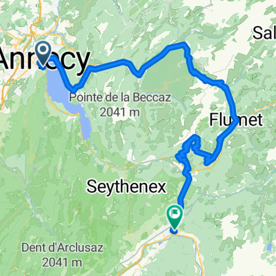
FORCLAZ MONTMIN VERSANT SUD 31MAI 2014
A cycling route starting in Annecy, Auvergne-Rhône-Alpes, France.
Overview
About this route
FORCLAZ MONTMIN VERSANT SUD MAY 31, 2014
-- Difficult slope -- numerous passages at 10, 11%- -:--
- Duration
- 54.5 km
- Distance
- 757 m
- Ascent
- 759 m
- Descent
- ---
- Avg. speed
- ---
- Max. altitude
Route quality
Waytypes & surfaces along the route
Waytypes
Road
17.4 km
(32 %)
Quiet road
4.9 km
(9 %)
Surfaces
Paved
45.8 km
(84 %)
Unpaved
1.6 km
(3 %)
Asphalt
45.2 km
(83 %)
Loose gravel
1.1 km
(2 %)
Route highlights
Points of interest along the route

Point of interest after 31.6 km
VUE LAC ANNECY
Continue with Bikemap
Use, edit, or download this cycling route
You would like to ride FORCLAZ MONTMIN VERSANT SUD 31MAI 2014 or customize it for your own trip? Here is what you can do with this Bikemap route:
Free features
- Save this route as favorite or in collections
- Copy & plan your own version of this route
- Sync your route with Garmin or Wahoo
Premium features
Free trial for 3 days, or one-time payment. More about Bikemap Premium.
- Navigate this route on iOS & Android
- Export a GPX / KML file of this route
- Create your custom printout (try it for free)
- Download this route for offline navigation
Discover more Premium features.
Get Bikemap PremiumFrom our community
Other popular routes starting in Annecy
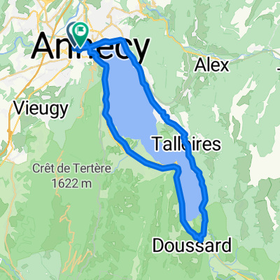 26-02 Rund um den Lac d'Annecy
- Distance
- 40.3 km
- Ascent
- 350 m
- Descent
- 346 m
- Location
- Annecy, Auvergne-Rhône-Alpes, France
 Tour of Lake Annecy
- Distance
- 39.9 km
- Ascent
- 320 m
- Descent
- 329 m
- Location
- Annecy, Auvergne-Rhône-Alpes, France
 Almenroute
- Distance
- 52.9 km
- Ascent
- 901 m
- Descent
- 992 m
- Location
- Annecy, Auvergne-Rhône-Alpes, France
 FORCLAZ MONTMIN VERSANT SUD 31MAI 2014
- Distance
- 54.5 km
- Ascent
- 757 m
- Descent
- 759 m
- Location
- Annecy, Auvergne-Rhône-Alpes, France
 Annecy lake round
- Distance
- 37.5 km
- Ascent
- 343 m
- Descent
- 343 m
- Location
- Annecy, Auvergne-Rhône-Alpes, France
 Rhone-Alpes: Etappe 1
- Distance
- 100.2 km
- Ascent
- 1,888 m
- Descent
- 1,997 m
- Location
- Annecy, Auvergne-Rhône-Alpes, France
 Day 1 - Annecy to Montgilbert
- Distance
- 60.9 km
- Ascent
- 767 m
- Descent
- 678 m
- Location
- Annecy, Auvergne-Rhône-Alpes, France
 Route in Annecy
- Distance
- 39.3 km
- Ascent
- 345 m
- Descent
- 347 m
- Location
- Annecy, Auvergne-Rhône-Alpes, France
Open it in the app