

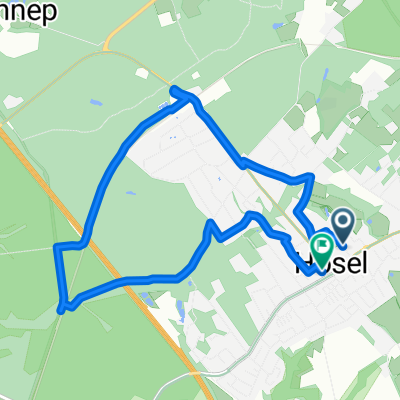
Panoramaweg Niederbergbahn Rundweg + Lokal
A cycling route starting in Heiligenhaus, North Rhine-Westphalia, Germany.
Overview
About this route
The Niederbergbahn Panorama Trail was opened in July 2011. It is 3 meters wide, paved, and crosses 16 bridges and 3 viaducts. In total, there are 250 meters of elevation to overcome, but it is family-friendly with gradients under 3%. Tour includes a lunch break at a very nice inn.
- -:--
- Duration
- 36.3 km
- Distance
- 287 m
- Ascent
- 289 m
- Descent
- ---
- Avg. speed
- ---
- Max. altitude
Route highlights
Points of interest along the route
Point of interest after 18.4 km
Restaurant Kleine Schweiz
Point of interest after 18.4 km
Mittagspause im Restaurant
Continue with Bikemap
Use, edit, or download this cycling route
You would like to ride Panoramaweg Niederbergbahn Rundweg + Lokal or customize it for your own trip? Here is what you can do with this Bikemap route:
Free features
- Save this route as favorite or in collections
- Copy & plan your own version of this route
- Sync your route with Garmin or Wahoo
Premium features
Free trial for 3 days, or one-time payment. More about Bikemap Premium.
- Navigate this route on iOS & Android
- Export a GPX / KML file of this route
- Create your custom printout (try it for free)
- Download this route for offline navigation
Discover more Premium features.
Get Bikemap PremiumFrom our community
Other popular routes starting in Heiligenhaus
 PanoramaRadweg niederbergbahn
- Distance
- 35.7 km
- Ascent
- 366 m
- Descent
- 203 m
- Location
- Heiligenhaus, North Rhine-Westphalia, Germany
 Stadtroute
- Distance
- 4.1 km
- Ascent
- 53 m
- Descent
- 47 m
- Location
- Heiligenhaus, North Rhine-Westphalia, Germany
 lumen Geländetestfahrt
- Distance
- 11.4 km
- Ascent
- 177 m
- Descent
- 228 m
- Location
- Heiligenhaus, North Rhine-Westphalia, Germany
 PanoramaRadweg niederbergbahn
- Distance
- 40.7 km
- Ascent
- 606 m
- Descent
- 429 m
- Location
- Heiligenhaus, North Rhine-Westphalia, Germany
 02 Esn.Kettwig Angertal Oberh. Holten
- Distance
- 61.2 km
- Ascent
- 379 m
- Descent
- 434 m
- Location
- Heiligenhaus, North Rhine-Westphalia, Germany
 Grüner Rundkurs Isenbügel-Heiligenhaus
- Distance
- 25.4 km
- Ascent
- 336 m
- Descent
- 336 m
- Location
- Heiligenhaus, North Rhine-Westphalia, Germany
 Route in Ratingen
- Distance
- 7.4 km
- Ascent
- 61 m
- Descent
- 63 m
- Location
- Heiligenhaus, North Rhine-Westphalia, Germany
 Essener Wasser Route mit aktuellen Umleitungen
- Distance
- 20.8 km
- Ascent
- 182 m
- Descent
- 189 m
- Location
- Heiligenhaus, North Rhine-Westphalia, Germany
Open it in the app