

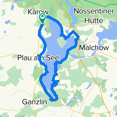
Rund um den Plauer See
A cycling route starting in Plau am See, Mecklenburg-Vorpommern, Germany.
Overview
About this route
Air spa Plau am See
· Castle tower from the 15th century with wall structure (landmark of the city with an 11 m deep dungeon)
· Castle with technical museum
· Plau Town Hall (Dutch Renaissance)
· Evangelical Church “St. Marien” (13th century, tower climbing possible)
· Sculpture Museum “Prof.Wandschneider”
· Lock facility with pedestrian bridge “Hühnerleiter”
· Historical drawbridge (monument, lift approx. 1.60 m)
· Historic old town
· Farmer's house (1756)
· Organ builder Nußbücker (visit possible)
· Water sports offers
· Waterway rest area “Stadthafen”
· Marina and sailing school
· Passenger shipping
· Boat service / boat rental
· Various bathing opportunities
· Bicycle rental
· Climbing park
· International sailing summer from April to September
· Plau Music Summer from June to September
· Gastronomy Plau Quetzin
· Beekeeping with bee museum (visit possible)
Karow
· “Karower Meiler” with cultural and information center
· Nature park administration
· Observation tower “Moorochse”
· NSG on the northern shore of Lake Plauer
Alt Schwerin
· Agricultural history museum
· Museum village
· Manor complex
· Butterfly house
· Gastronomy Wendorf
· Fishing with restaurant
· Passenger shipping Lenz
· Bathing opportunity
· Panoramic view from Lenzer Höh
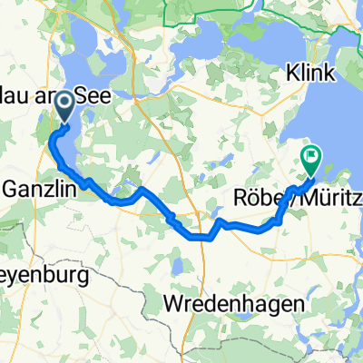
Detour:
Zislow
· Chapel (15th century) with exhibitions
· Megalithic tombs
· Bathing opportunity
· Kiosk
· Riding opportunities
Bad Stuer
· Half-timbered church (18th century) · Megalithic tomb · Tumulus
· Ruins of the castle
· NSG “Valley of the Kingfishers”
· Trout ponds
· Boat dock
· Bathing opportunity
· Gastronomy
Stuer
· Bear forest Müritz with bio-bistro
Track characteristics:
Surface ranging from asphalt to sand, almost always right by the lake, natural, southeast bank path sometimes difficult (roots, wet spots)
- -:--
- Duration
- 49 km
- Distance
- 154 m
- Ascent
- 154 m
- Descent
- ---
- Avg. speed
- ---
- Max. altitude

Route quality
Waytypes & surfaces along the route
Waytypes
Path
19.1 km
(39 %)
Quiet road
11.3 km
(23 %)
Surfaces
Paved
16.2 km
(33 %)
Unpaved
20.1 km
(41 %)
Asphalt
12.2 km
(25 %)
Ground
9.8 km
(20 %)
Continue with Bikemap
Use, edit, or download this cycling route
You would like to ride Rund um den Plauer See or customize it for your own trip? Here is what you can do with this Bikemap route:
Free features
- Save this route as favorite or in collections
- Copy & plan your own version of this route
- Sync your route with Garmin or Wahoo
Premium features
Free trial for 3 days, or one-time payment. More about Bikemap Premium.
- Navigate this route on iOS & Android
- Export a GPX / KML file of this route
- Create your custom printout (try it for free)
- Download this route for offline navigation
Discover more Premium features.
Get Bikemap PremiumFrom our community
Other popular routes starting in Plau am See
 Rund um den Plauer See
- Distance
- 49 km
- Ascent
- 172 m
- Descent
- 172 m
- Location
- Plau am See, Mecklenburg-Vorpommern, Germany
 Waren - Rechlin
- Distance
- 37.4 km
- Ascent
- 217 m
- Descent
- 219 m
- Location
- Plau am See, Mecklenburg-Vorpommern, Germany
 Drewitzer See
- Distance
- 26.5 km
- Ascent
- 121 m
- Descent
- 120 m
- Location
- Plau am See, Mecklenburg-Vorpommern, Germany
 1 _ MSPx4 _ Plau am See - Roez
- Distance
- 47.8 km
- Ascent
- 371 m
- Descent
- 355 m
- Location
- Plau am See, Mecklenburg-Vorpommern, Germany
 Malchow - Warnemünde
- Distance
- 95.7 km
- Ascent
- 430 m
- Descent
- 493 m
- Location
- Plau am See, Mecklenburg-Vorpommern, Germany
 Rund um den Plauer See
- Distance
- 49 km
- Ascent
- 154 m
- Descent
- 154 m
- Location
- Plau am See, Mecklenburg-Vorpommern, Germany
 Quetziner Straße 72A nach Quetziner Straße 72A
- Distance
- 45 km
- Ascent
- 223 m
- Descent
- 265 m
- Location
- Plau am See, Mecklenburg-Vorpommern, Germany
 Plau am See
- Distance
- 42.4 km
- Ascent
- 1,005 m
- Descent
- 1,024 m
- Location
- Plau am See, Mecklenburg-Vorpommern, Germany
Open it in the app