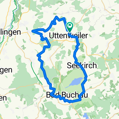
von Uttenweiler nach Kirchberg/Iller
A cycling route starting in Uttenweiler, Baden-Wurttemberg, Germany.
Overview
About this route
Route off the roads through the Upper Swabian cycling paradise
- -:--
- Duration
- 53.1 km
- Distance
- 333 m
- Ascent
- 340 m
- Descent
- ---
- Avg. speed
- 605 m
- Max. altitude
Route quality
Waytypes & surfaces along the route
Waytypes
Quiet road
22.8 km
(43 %)
Track
21.8 km
(41 %)
Surfaces
Paved
32.9 km
(62 %)
Unpaved
13.3 km
(25 %)
Asphalt
28.1 km
(53 %)
Gravel
7.4 km
(14 %)
Continue with Bikemap
Use, edit, or download this cycling route
You would like to ride von Uttenweiler nach Kirchberg/Iller or customize it for your own trip? Here is what you can do with this Bikemap route:
Free features
- Save this route as favorite or in collections
- Copy & plan your own version of this route
- Sync your route with Garmin or Wahoo
Premium features
Free trial for 3 days, or one-time payment. More about Bikemap Premium.
- Navigate this route on iOS & Android
- Export a GPX / KML file of this route
- Create your custom printout (try it for free)
- Download this route for offline navigation
Discover more Premium features.
Get Bikemap PremiumFrom our community
Other popular routes starting in Uttenweiler
- Samstagtour 20120623
- Distance
- 52.9 km
- Ascent
- 393 m
- Descent
- 393 m
- Location
- Uttenweiler, Baden-Wurttemberg, Germany
- Oberschwaben 2
- Distance
- 48.9 km
- Ascent
- 223 m
- Descent
- 194 m
- Location
- Uttenweiler, Baden-Wurttemberg, Germany
- über Schupfenberg und Bussen
- Distance
- 31.9 km
- Ascent
- 465 m
- Descent
- 465 m
- Location
- Uttenweiler, Baden-Wurttemberg, Germany
- Norden
- Distance
- 37.5 km
- Ascent
- 335 m
- Descent
- 335 m
- Location
- Uttenweiler, Baden-Wurttemberg, Germany
- 20130702 Bussen Federsee
- Distance
- 45.7 km
- Ascent
- 336 m
- Descent
- 336 m
- Location
- Uttenweiler, Baden-Wurttemberg, Germany
- Alptour
- Distance
- 63.4 km
- Ascent
- 562 m
- Descent
- 557 m
- Location
- Uttenweiler, Baden-Wurttemberg, Germany
- Burren-Runde - 20130528
- Distance
- 32.1 km
- Ascent
- 357 m
- Descent
- 351 m
- Location
- Uttenweiler, Baden-Wurttemberg, Germany
- ..durch die Wälder
- Distance
- 49.8 km
- Ascent
- 423 m
- Descent
- 421 m
- Location
- Uttenweiler, Baden-Wurttemberg, Germany
Open it in the app