

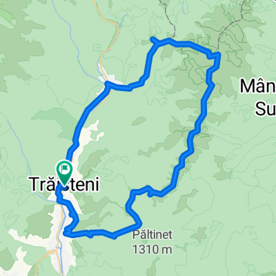
traisteni-negrasu-ulita-radila-tesila
A cycling route starting in Trăisteni, Prahova, Romania.
Overview
About this route
Southern summit of the debris
- -:--
- Duration
- 33.1 km
- Distance
- 824 m
- Ascent
- 862 m
- Descent
- ---
- Avg. speed
- ---
- Max. altitude
Continue with Bikemap
Use, edit, or download this cycling route
You would like to ride traisteni-negrasu-ulita-radila-tesila or customize it for your own trip? Here is what you can do with this Bikemap route:
Free features
- Save this route as favorite or in collections
- Copy & plan your own version of this route
- Sync your route with Garmin or Wahoo
Premium features
Free trial for 3 days, or one-time payment. More about Bikemap Premium.
- Navigate this route on iOS & Android
- Export a GPX / KML file of this route
- Create your custom printout (try it for free)
- Download this route for offline navigation
Discover more Premium features.
Get Bikemap PremiumFrom our community
Other popular routes starting in Trăisteni
 VALEA DOFTANEI
- Distance
- 34.4 km
- Ascent
- 1,163 m
- Descent
- 1,155 m
- Location
- Trăisteni, Prahova, Romania
 lacul Orjogoaia
- Distance
- 17 km
- Ascent
- 971 m
- Descent
- 954 m
- Location
- Trăisteni, Prahova, Romania
 traisteni-negrasu-ulita-radila-tesila
- Distance
- 33.1 km
- Ascent
- 824 m
- Descent
- 862 m
- Location
- Trăisteni, Prahova, Romania
 17.08
17.08- Distance
- 35.7 km
- Ascent
- 1,206 m
- Descent
- 1,213 m
- Location
- Trăisteni, Prahova, Romania
 Valea Doftanei-Baiului-Secaria-Valea Doftanei
- Distance
- 52.8 km
- Ascent
- 1,373 m
- Descent
- 1,374 m
- Location
- Trăisteni, Prahova, Romania
 V. Doftanei - Azuga(+ rosu, Orjogoaia)
- Distance
- 21.8 km
- Ascent
- 809 m
- Descent
- 702 m
- Location
- Trăisteni, Prahova, Romania
 Strada Malul cu Flori to Strada Malul cu Flori
- Distance
- 51.6 km
- Ascent
- 1,895 m
- Descent
- 1,895 m
- Location
- Trăisteni, Prahova, Romania
 Grohotis - sud - Valea Doftanei
- Distance
- 32.1 km
- Ascent
- 927 m
- Descent
- 927 m
- Location
- Trăisteni, Prahova, Romania
Open it in the app