

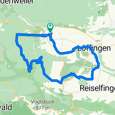
Schwarzwaldrunde
A cycling route starting in Löffingen, Baden-Wurttemberg, Germany.
Overview
About this route
beautiful Schwarzwald loop3
- -:--
- Duration
- 53.4 km
- Distance
- 734 m
- Ascent
- 698 m
- Descent
- ---
- Avg. speed
- 1,009 m
- Max. altitude

Route quality
Waytypes & surfaces along the route
Waytypes
Road
21.3 km
(40 %)
Quiet road
5.3 km
(10 %)
Surfaces
Paved
44.3 km
(83 %)
Asphalt
42.7 km
(80 %)
Paved (undefined)
1.6 km
(3 %)
Undefined
9.1 km
(17 %)
Route highlights
Points of interest along the route
Point of interest after 11.7 km
Kirnbergsee
Continue with Bikemap
Use, edit, or download this cycling route
You would like to ride Schwarzwaldrunde or customize it for your own trip? Here is what you can do with this Bikemap route:
Free features
- Save this route as favorite or in collections
- Copy & plan your own version of this route
- Sync your route with Garmin or Wahoo
Premium features
Free trial for 3 days, or one-time payment. More about Bikemap Premium.
- Navigate this route on iOS & Android
- Export a GPX / KML file of this route
- Create your custom printout (try it for free)
- Download this route for offline navigation
Discover more Premium features.
Get Bikemap PremiumFrom our community
Other popular routes starting in Löffingen
 Schwarzwaldrunde
- Distance
- 53.4 km
- Ascent
- 734 m
- Descent
- 698 m
- Location
- Löffingen, Baden-Wurttemberg, Germany
 bbb
bbb- Distance
- 22.9 km
- Ascent
- 325 m
- Descent
- 322 m
- Location
- Löffingen, Baden-Wurttemberg, Germany
 Rund um den Feldberg
- Distance
- 120.9 km
- Ascent
- 2,056 m
- Descent
- 2,050 m
- Location
- Löffingen, Baden-Wurttemberg, Germany
 Panoramaroute
- Distance
- 43.5 km
- Ascent
- 480 m
- Descent
- 480 m
- Location
- Löffingen, Baden-Wurttemberg, Germany
 3 Tages Biketour Südschwarzwald für MTB von H.R.S.T.
- Distance
- 120 km
- Ascent
- 1,587 m
- Descent
- 2,115 m
- Location
- Löffingen, Baden-Wurttemberg, Germany
 Durch Wald und Flur zur Wallfahrtskapelle zum „Witterschneekreuz“.
- Distance
- 11.2 km
- Ascent
- 88 m
- Descent
- 88 m
- Location
- Löffingen, Baden-Wurttemberg, Germany
 Löffingen - Möhringen
- Distance
- 52.1 km
- Ascent
- 141 m
- Descent
- 298 m
- Location
- Löffingen, Baden-Wurttemberg, Germany
 von Löffingen über Friedenweiler und Eisenbach...
- Distance
- 41.4 km
- Ascent
- 624 m
- Descent
- 623 m
- Location
- Löffingen, Baden-Wurttemberg, Germany
Open it in the app