Benilloba - Confrides - Benidorm - Tudons - Penáguila - Xixona - La Carrasqueta - Alcoi - Benilloba
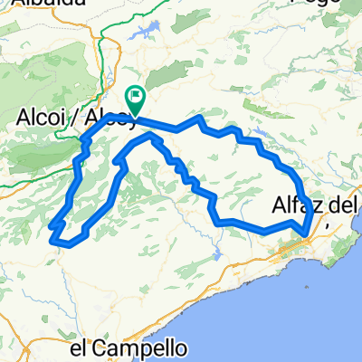
A cycling route starting in Benilloba, Valencia, Spain.
Overview
About this route
Ruta circular, larga y con mucho desnivel... Ensayo general para la Quebrantahuesos
- -:--
- Duration
- 137.9 km
- Distance
- 2,406 m
- Ascent
- 2,406 m
- Descent
- ---
- Avg. speed
- ---
- Max. altitude
Route quality
Waytypes & surfaces along the route
Waytypes
Busy road
126.8 km
(92 %)
Cycleway
6 km
(4 %)
Surfaces
Paved
43.8 km
(32 %)
Asphalt
43.8 km
(32 %)
Undefined
94.2 km
(68 %)
Continue with Bikemap
Use, edit, or download this cycling route
You would like to ride Benilloba - Confrides - Benidorm - Tudons - Penáguila - Xixona - La Carrasqueta - Alcoi - Benilloba or customize it for your own trip? Here is what you can do with this Bikemap route:
Free features
- Save this route as favorite or in collections
- Copy & plan your own version of this route
- Split it into stages to create a multi-day tour
- Sync your route with Garmin or Wahoo
Premium features
Free trial for 3 days, or one-time payment. More about Bikemap Premium.
- Navigate this route on iOS & Android
- Export a GPX / KML file of this route
- Create your custom printout (try it for free)
- Download this route for offline navigation
Discover more Premium features.
Get Bikemap PremiumFrom our community
Other popular routes starting in Benilloba
- Benilloba - Confrides - Benidorm - Tudons - Penáguila - Xixona - La Carrasqueta - Alcoi - Benilloba
- Distance
- 137.9 km
- Ascent
- 2,406 m
- Descent
- 2,406 m
- Location
- Benilloba, Valencia, Spain
- Tudons por Bellinoba
- Distance
- 13.1 km
- Ascent
- 663 m
- Descent
- 175 m
- Location
- Benilloba, Valencia, Spain
- De Partida Solanas 15, Penà guila a Carrer Lope de Vega 8, Benilloba
- Distance
- 2.1 km
- Ascent
- 193 m
- Descent
- 285 m
- Location
- Benilloba, Valencia, Spain
- Calle Calderón de la Barca, 4, Benilloba a Calle Calderón de la Barca, 4, Benilloba
- Distance
- 4.3 km
- Ascent
- 48 m
- Descent
- 50 m
- Location
- Benilloba, Valencia, Spain
- Alicante 3 light
- Distance
- 81.6 km
- Ascent
- 878 m
- Descent
- 1,118 m
- Location
- Benilloba, Valencia, Spain
- concentaina castell
- Distance
- 71 km
- Ascent
- 1,124 m
- Descent
- 1,098 m
- Location
- Benilloba, Valencia, Spain
- ARES, por Benasau
- Distance
- 10.4 km
- Ascent
- 516 m
- Descent
- 78 m
- Location
- Benilloba, Valencia, Spain
- RUTA PALMEROS AGOST 2013
- Distance
- 115.6 km
- Ascent
- 2,183 m
- Descent
- 2,183 m
- Location
- Benilloba, Valencia, Spain
Open it in the app