

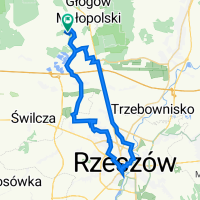
2014/6 Bór Głogowski - Głogów Młp. - Jańciówka - Tajęcina
A cycling route starting in Głogów Małopolski, Subcarpathian Voivodeship, Poland.
Overview
About this route
Trasa przejechana 08 czerwca 2014r.
- -:--
- Duration
- 26.7 km
- Distance
- 107 m
- Ascent
- 107 m
- Descent
- ---
- Avg. speed
- ---
- Avg. speed
Route highlights
Points of interest along the route

Point of interest after 1.5 km
Rezerwat Przyrody Bór, tablice informacyjne

Point of interest after 2.7 km
Widok na osiedle Głogowa w kierunku W.

Point of interest after 3.7 km
Głogów Małopolski (Borsuk Drugi), widok w kierunku E.

Point of interest after 4.2 km
Głogów Małopolski (Borsuk Pierwszy), krzyż przydrożny.

Point of interest after 4.8 km
Głogów Małopolski, Figura NMP .

Point of interest after 5.1 km
Głogów Małopolski, widok w kierunku W.

Point of interest after 5.3 km
Głogów Małopolski, widok na ratusz.

Point of interest after 5.4 km
Głogów Małopolski

Point of interest after 5.7 km
Głogów Małopolski, kapliczka przydrożna.

Point of interest after 6.4 km
Widok w kierunku W.

Point of interest after 6.6 km
Głogów Małopolski (Wygoda).

Point of interest after 7.2 km
Głogów Małopolski (Wygoda).

Point of interest after 8.1 km
Jańciówka, widok w kierunku NNE.

Point of interest after 8.1 km
Jańciówka, polne kwiaty w pszenicy.

Point of interest after 10.2 km
Jańciówka

Point of interest after 12.6 km
Brzegi, widok w kierunku N.

Point of interest after 14.7 km
Leśna kapliczka na drzewie.

Point of interest after 15 km
Wysoka Głogowska, rzeka Gołębiówka.

Point of interest after 15 km
Wysoka Głogowska

Point of interest after 15.3 km
Wysoka Głogowska, mogiła obok leśniczówki.

Point of interest after 15.8 km
Wysoka Głogowska,kapliczka.

Point of interest after 16 km
Wysoka Głogowska, krzyż przydrożny.

Point of interest after 16 km
Wysoka Głogowska, rzeka Gołębiówka.

Point of interest after 17.6 km
Wysoka Głogowska

Point of interest after 17.8 km
Wysoka Głogowska, widok na park i dwór.

Point of interest after 18.2 km
Wysoka Głogowska

Point of interest after 18.8 km
Wysoka Głogowska

Point of interest after 19 km
Rzeka Gołębiówka

Point of interest after 19.1 km
Wysoka Głogowska

Point of interest after 19.7 km
Okazały dąb przy gospodarstwie.

Point of interest after 20.2 km
Krzyż przydrożny

Point of interest after 21.9 km
Tajęcina

Point of interest after 22 km
Tajęcina

Point of interest after 23 km
Tajęcina, centrum rehabilitacji.

Point of interest after 23.9 km
Zakład gazowniczy, Bór Głogowski.
Continue with Bikemap
Use, edit, or download this cycling route
You would like to ride 2014/6 Bór Głogowski - Głogów Młp. - Jańciówka - Tajęcina or customize it for your own trip? Here is what you can do with this Bikemap route:
Free features
- Save this route as favorite or in collections
- Copy & plan your own version of this route
- Sync your route with Garmin or Wahoo
Premium features
Free trial for 3 days, or one-time payment. More about Bikemap Premium.
- Navigate this route on iOS & Android
- Export a GPX / KML file of this route
- Create your custom printout (try it for free)
- Download this route for offline navigation
Discover more Premium features.
Get Bikemap PremiumFrom our community
Other popular routes starting in Głogów Małopolski
 AZALIA PONTYJSKA W KOŁACZNI
- Distance
- 103.4 km
- Ascent
- 147 m
- Descent
- 215 m
- Location
- Głogów Małopolski, Subcarpathian Voivodeship, Poland
 2013/10 Głogów MŁp. - Turza N. - Nienadówka
- Distance
- 37.8 km
- Ascent
- 163 m
- Descent
- 166 m
- Location
- Głogów Małopolski, Subcarpathian Voivodeship, Poland
 Rzeszowska 90, Rudna Mała do Droga bez nazwy, Wysoka Głogowska
- Distance
- 5.6 km
- Ascent
- 7 m
- Descent
- 43 m
- Location
- Głogów Małopolski, Subcarpathian Voivodeship, Poland
 bieg w borze
- Distance
- 30.9 km
- Ascent
- 134 m
- Descent
- 130 m
- Location
- Głogów Małopolski, Subcarpathian Voivodeship, Poland
 Zabajka- strefa Dworzysko- rynek Rzeszów- Zabajka
- Distance
- 35.6 km
- Ascent
- 114 m
- Descent
- 116 m
- Location
- Głogów Małopolski, Subcarpathian Voivodeship, Poland
 Galicja Gravel Race 500 18.07
- Distance
- 502.7 km
- Ascent
- 1,608 m
- Descent
- 1,604 m
- Location
- Głogów Małopolski, Subcarpathian Voivodeship, Poland
 Teoretyczna trasa Łemko
- Distance
- 405 km
- Ascent
- 5,005 m
- Descent
- 4,995 m
- Location
- Głogów Małopolski, Subcarpathian Voivodeship, Poland
 Zabajka- lotnisko- Zapole- Zabajka
- Distance
- 31.3 km
- Ascent
- 122 m
- Descent
- 121 m
- Location
- Głogów Małopolski, Subcarpathian Voivodeship, Poland
Open it in the app