

Harz
Wernigerode HarzW-134km (RK) Königsetappe
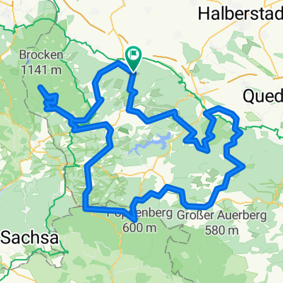
A cycling route starting in Wernigerode, Saxony-Anhalt, Germany.
Overview
About this route
On 31.05.2014 (Sat), rode with Team Langen with 8 bikers (4 riders shortened the tour at Braunlage).
- -:--
- Duration
- 133.8 km
- Distance
- 1,425 m
- Ascent
- 1,425 m
- Descent
- ---
- Avg. speed
- ---
- Max. altitude
Part of
Harz
14 stages
Route quality
Waytypes & surfaces along the route
Waytypes
Road
14.7 km
(11 %)
Path
9.4 km
(7 %)
Surfaces
Paved
121.8 km
(91 %)
Asphalt
121.8 km
(91 %)
Undefined
12 km
(9 %)
Route highlights
Points of interest along the route
 Königsetappe\"")
Point of interest after 37.1 km
1. Pause (nach 36 gef. km) an der Okertalsperre.
 Königsetappe\"")
Point of interest after 60.9 km
2. Pause (nach 59 gef. km) in Altenau am Marktstübchen (Weizenbier).
Continue with Bikemap
Use, edit, or download this cycling route
You would like to ride Wernigerode HarzW-134km (RK) Königsetappe or customize it for your own trip? Here is what you can do with this Bikemap route:
Free features
- Save this route as favorite or in collections
- Copy & plan your own version of this route
- Split it into stages to create a multi-day tour
- Sync your route with Garmin or Wahoo
Premium features
Free trial for 3 days, or one-time payment. More about Bikemap Premium.
- Navigate this route on iOS & Android
- Export a GPX / KML file of this route
- Create your custom printout (try it for free)
- Download this route for offline navigation
Discover more Premium features.
Get Bikemap PremiumFrom our community
Other popular routes starting in Wernigerode
 Wernigerode HarzW-134km (RK) Königsetappe
- Distance
- 133.8 km
- Ascent
- 1,425 m
- Descent
- 1,425 m
- Location
- Wernigerode, Saxony-Anhalt, Germany
 Eine kleine Abendrunde bei Wernigerode
- Distance
- 24.2 km
- Ascent
- 125 m
- Descent
- 125 m
- Location
- Wernigerode, Saxony-Anhalt, Germany
 Wernigerode: Brocken rauf und runter
- Distance
- 57.5 km
- Ascent
- 1,079 m
- Descent
- 1,078 m
- Location
- Wernigerode, Saxony-Anhalt, Germany
 Wernigerode - Brocken - Bad Harzburg - Wernigerode
- Distance
- 91.4 km
- Ascent
- 1,313 m
- Descent
- 1,313 m
- Location
- Wernigerode, Saxony-Anhalt, Germany
 Wernigerode -> Walkenried -> Thale Hbf.
- Distance
- 94.4 km
- Ascent
- 1,169 m
- Descent
- 1,017 m
- Location
- Wernigerode, Saxony-Anhalt, Germany
 Brocken
- Distance
- 19.3 km
- Ascent
- 1,037 m
- Descent
- 157 m
- Location
- Wernigerode, Saxony-Anhalt, Germany
 Wernigerode HarzW-126km (RK)
- Distance
- 125.4 km
- Ascent
- 1,866 m
- Descent
- 1,550 m
- Location
- Wernigerode, Saxony-Anhalt, Germany
 Brockenrunde
- Distance
- 153 km
- Ascent
- 2,210 m
- Descent
- 2,116 m
- Location
- Wernigerode, Saxony-Anhalt, Germany
Open it in the app