

Ufford to Gorleston
A cycling route starting in Wickham Market, England, United Kingdom.
Overview
About this route
Cross country from Ufford to Gorleston, bit of A12
- -:--
- Duration
- 81.3 km
- Distance
- 218 m
- Ascent
- 220 m
- Descent
- ---
- Avg. speed
- ---
- Max. altitude
Route quality
Waytypes & surfaces along the route
Waytypes
Quiet road
29.3 km
(36 %)
Cycleway
8.9 km
(11 %)
Surfaces
Paved
10.6 km
(13 %)
Asphalt
10.6 km
(13 %)
Undefined
70.8 km
(87 %)
Continue with Bikemap
Use, edit, or download this cycling route
You would like to ride Ufford to Gorleston or customize it for your own trip? Here is what you can do with this Bikemap route:
Free features
- Save this route as favorite or in collections
- Copy & plan your own version of this route
- Split it into stages to create a multi-day tour
- Sync your route with Garmin or Wahoo
Premium features
Free trial for 3 days, or one-time payment. More about Bikemap Premium.
- Navigate this route on iOS & Android
- Export a GPX / KML file of this route
- Create your custom printout (try it for free)
- Download this route for offline navigation
Discover more Premium features.
Get Bikemap PremiumFrom our community
Other popular routes starting in Wickham Market
 Leg two to the end
- Distance
- 33 km
- Ascent
- 105 m
- Descent
- 123 m
- Location
- Wickham Market, England, United Kingdom
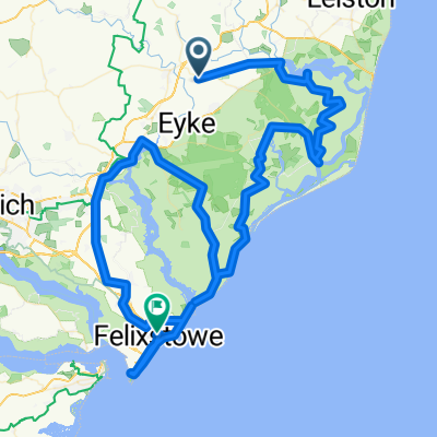 Wickham Market to Felixstowe
- Distance
- 105 km
- Ascent
- 213 m
- Descent
- 219 m
- Location
- Wickham Market, England, United Kingdom
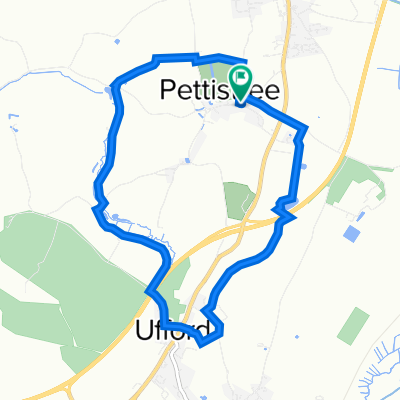
 WALK Pettistree-Ufford Circular
- Distance
- 10.1 km
- Ascent
- 75 m
- Descent
- 74 m
- Location
- Wickham Market, England, United Kingdom
 WALK - Greyhound Byng Brook (4.5 miles)
- Distance
- 7.3 km
- Ascent
- 30 m
- Descent
- 32 m
- Location
- Wickham Market, England, United Kingdom
 1–15 Wood Close, Rendlesham, Woodbridge to 49 Kelvin Road, Ipswich
- Distance
- 25.2 km
- Ascent
- 164 m
- Descent
- 170 m
- Location
- Wickham Market, England, United Kingdom
 Felixstowe Circuit 37miles
- Distance
- 58.9 km
- Ascent
- 260 m
- Descent
- 269 m
- Location
- Wickham Market, England, United Kingdom
 Ufford to Gorleston
- Distance
- 81.3 km
- Ascent
- 218 m
- Descent
- 220 m
- Location
- Wickham Market, England, United Kingdom
 Wickham Market Framlingham28m
- Distance
- 44.4 km
- Ascent
- 254 m
- Descent
- 258 m
- Location
- Wickham Market, England, United Kingdom
Open it in the app