

Vlčický triatlon týmu - BIKE
A cycling route starting in Haugschlag, Lower Austria, Austria.
Overview
About this route
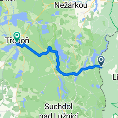
The mountain bike circuit for teams at the Vlčice triathlon, leading from the Vlčice campsite to Fabián and back.
- -:--
- Duration
- 14.9 km
- Distance
- 226 m
- Ascent
- 226 m
- Descent
- ---
- Avg. speed
- ---
- Max. altitude

Route quality
Waytypes & surfaces along the route
Waytypes
Track
14.9 km
(100 %)
Surfaces
Paved
10.5 km
(71 %)
Unpaved
4.3 km
(29 %)
Asphalt
5.8 km
(39 %)
Paved (undefined)
3.9 km
(26 %)
Continue with Bikemap
Use, edit, or download this cycling route
You would like to ride Vlčický triatlon týmu - BIKE or customize it for your own trip? Here is what you can do with this Bikemap route:
Free features
- Save this route as favorite or in collections
- Copy & plan your own version of this route
- Sync your route with Garmin or Wahoo
Premium features
Free trial for 3 days, or one-time payment. More about Bikemap Premium.
- Navigate this route on iOS & Android
- Export a GPX / KML file of this route
- Create your custom printout (try it for free)
- Download this route for offline navigation
Discover more Premium features.
Get Bikemap PremiumFrom our community
Other popular routes starting in Haugschlag
 Hörmanns Tour 2
- Distance
- 41.4 km
- Ascent
- 396 m
- Descent
- 396 m
- Location
- Haugschlag, Lower Austria, Austria
 schlag-trebon2
- Distance
- 22.8 km
- Ascent
- 62 m
- Descent
- 122 m
- Location
- Haugschlag, Lower Austria, Austria
 Vlčický triatlon týmu - BIKE
- Distance
- 14.9 km
- Ascent
- 226 m
- Descent
- 226 m
- Location
- Haugschlag, Lower Austria, Austria
 Kanada Tschechiens Haugschlag
- Distance
- 67.7 km
- Ascent
- 589 m
- Descent
- 589 m
- Location
- Haugschlag, Lower Austria, Austria
 Haugschlag - Gmünd
- Distance
- 44.7 km
- Ascent
- 331 m
- Descent
- 447 m
- Location
- Haugschlag, Lower Austria, Austria
 Tag02
Tag02- Distance
- 117.2 km
- Ascent
- 726 m
- Descent
- 726 m
- Location
- Haugschlag, Lower Austria, Austria
 Saaß 19, Litschau nach náměstí Míru, Zlabings
- Distance
- 35.7 km
- Ascent
- 386 m
- Descent
- 430 m
- Location
- Haugschlag, Lower Austria, Austria
 Route nach Staňkov
- Distance
- 8 km
- Ascent
- 18 m
- Descent
- 121 m
- Location
- Haugschlag, Lower Austria, Austria
Open it in the app