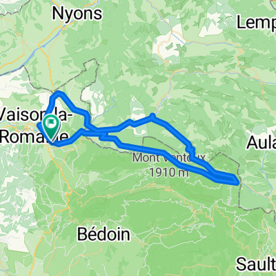
- 74.3 km
- 2,489 m
- 2,068 m
- Vaison-la-Romaine, Provence-Alpes-C么te d'Azur Region, France
e4 Ascension du Ventoux par Malauc猫ne
A cycling route starting in Vaison-la-Romaine, Provence-Alpes-C么te d'Azur Region, France.
Overview
About this route
Great route! Warning, the editor rejects the start of the small road (no entry except residents) that avoids Malauc猫ne on the return... Do not follow the trace at this point and take the small road directly from the D938.
- -:--
- Duration
- 69.6 km
- Distance
- 1,819 m
- Ascent
- 1,819 m
- Descent
- ---
- Avg. speed
- ---
- Max. altitude
created this 11 years ago
Route quality
Waytypes & surfaces along the route
Waytypes
Quiet road
5.6 km
(8 %)
Track
1.4 km
(2 %)
Surfaces
Paved
62 km
(89 %)
Asphalt
62 km
(89 %)
Undefined
7.7 km
(11 %)
Continue with Bikemap
Use, edit, or download this cycling route
You would like to ride e4 Ascension du Ventoux par Malauc猫ne or customize it for your own trip? Here is what you can do with this Bikemap route:
Free features
- Save this route as favorite or in collections
- Copy & plan your own version of this route
- Sync your route with Garmin or Wahoo
Premium features
Free trial for 3 days, or one-time payment. More about Bikemap Premium.
- Navigate this route on iOS & Android
- Export a GPX / KML file of this route
- Create your custom printout (try it for free)
- Download this route for offline navigation
Discover more Premium features.
Get Bikemap PremiumFrom our community
Other popular routes starting in Vaison-la-Romaine
- Mont Ventoux
- Mont Ventoux
- 97.8 km
- 1,943 m
- 1,945 m
- Vaison-la-Romaine, Provence-Alpes-C么te d'Azur Region, France
- Prolog
- 39.8 km
- 499 m
- 475 m
- Vaison-la-Romaine, Provence-Alpes-C么te d'Azur Region, France
- 48 km Malauc猫ne Beaume Vacqueyras 560 m
- 48 km
- 538 m
- 534 m
- Vaison-la-Romaine, Provence-Alpes-C么te d'Azur Region, France
- 2013-07-16: Vaison-la-Romaine - Gap
- 130.8 km
- 1,552 m
- 1,024 m
- Vaison-la-Romaine, Provence-Alpes-C么te d'Azur Region, France
- Vaison-la-Romaine in die Berge 70km
- 69.3 km
- 1,683 m
- 1,683 m
- Vaison-la-Romaine, Provence-Alpes-C么te d'Azur Region, France
- F49-VaisonEntrechauxSavoillanEygaliersPymerasVaison
- 67 km
- 1,571 m
- 1,571 m
- Vaison-la-Romaine, Provence-Alpes-C么te d'Azur Region, France
- Route in Vaison-la-Romaine
- 62.3 km
- 1,260 m
- 1,274 m
- Vaison-la-Romaine, Provence-Alpes-C么te d'Azur Region, France
Open it in the app


