

1-Heldenstein-Altmühltal
A cycling route starting in Rattenkirchen, Bavaria, Germany.
Overview
About this route
- Section
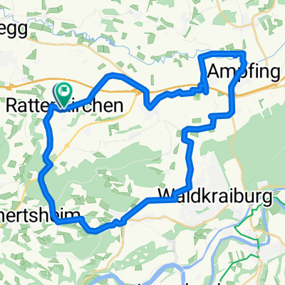
Heldenstein-Rottenburg/Laaber 71 km
- -:--
- Duration
- 70.8 km
- Distance
- 505 m
- Ascent
- 507 m
- Descent
- ---
- Avg. speed
- 517 m
- Max. altitude
Route quality
Waytypes & surfaces along the route
Waytypes
Quiet road
9.2 km
(13 %)
Road
7.8 km
(11 %)
Surfaces
Paved
65.1 km
(92 %)
Unpaved
1.4 km
(2 %)
Asphalt
65.1 km
(92 %)
Gravel
1.4 km
(2 %)
Undefined
4.2 km
(6 %)
Continue with Bikemap
Use, edit, or download this cycling route
You would like to ride 1-Heldenstein-Altmühltal or customize it for your own trip? Here is what you can do with this Bikemap route:
Free features
- Save this route as favorite or in collections
- Copy & plan your own version of this route
- Sync your route with Garmin or Wahoo
Premium features
Free trial for 3 days, or one-time payment. More about Bikemap Premium.
- Navigate this route on iOS & Android
- Export a GPX / KML file of this route
- Create your custom printout (try it for free)
- Download this route for offline navigation
Discover more Premium features.
Get Bikemap PremiumFrom our community
Other popular routes starting in Rattenkirchen
 Route 26
- Distance
- 34.2 km
- Ascent
- 226 m
- Descent
- 225 m
- Location
- Rattenkirchen, Bavaria, Germany
 Heldensteiner Berg und Tal
- Distance
- 46 km
- Ascent
- 614 m
- Descent
- 614 m
- Location
- Rattenkirchen, Bavaria, Germany
 160708 R'kirchn - Freibad AÖ
- Distance
- 50.5 km
- Ascent
- 182 m
- Descent
- 257 m
- Location
- Rattenkirchen, Bavaria, Germany
 Heldenstein: 15
- Distance
- 32 km
- Ascent
- 455 m
- Descent
- 456 m
- Location
- Rattenkirchen, Bavaria, Germany
 kleine Isentour
- Distance
- 17.6 km
- Ascent
- 102 m
- Descent
- 129 m
- Location
- Rattenkirchen, Bavaria, Germany
 B12 - Glatzberg
- Distance
- 16.5 km
- Ascent
- 177 m
- Descent
- 141 m
- Location
- Rattenkirchen, Bavaria, Germany
 Isentalrunde
- Distance
- 27.9 km
- Ascent
- 279 m
- Descent
- 278 m
- Location
- Rattenkirchen, Bavaria, Germany
 Heldenstein - Weidenbach - Stefanskirchen - Peizabruck
- Distance
- 15.9 km
- Ascent
- 137 m
- Descent
- 138 m
- Location
- Rattenkirchen, Bavaria, Germany
Open it in the app