
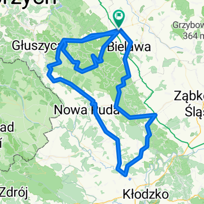
Walim-Jezioro-Złoty Las-Wiry-Kiełczyn
A cycling route starting in Pieszyce, Lower Silesian Voivodeship, Poland.
Overview
About this route
Walim-Lake-Golden Forest-Wiry-Kiełczyn
- -:--
- Duration
- 61 km
- Distance
- 669 m
- Ascent
- 829 m
- Descent
- ---
- Avg. speed
- ---
- Max. altitude
Route quality
Waytypes & surfaces along the route
Waytypes
Road
28.7 km
(47 %)
Quiet road
14.6 km
(24 %)
Surfaces
Paved
43.3 km
(71 %)
Asphalt
43.3 km
(71 %)
Undefined
17.7 km
(29 %)
Continue with Bikemap
Use, edit, or download this cycling route
You would like to ride Walim-Jezioro-Złoty Las-Wiry-Kiełczyn or customize it for your own trip? Here is what you can do with this Bikemap route:
Free features
- Save this route as favorite or in collections
- Copy & plan your own version of this route
- Sync your route with Garmin or Wahoo
Premium features
Free trial for 3 days, or one-time payment. More about Bikemap Premium.
- Navigate this route on iOS & Android
- Export a GPX / KML file of this route
- Create your custom printout (try it for free)
- Download this route for offline navigation
Discover more Premium features.
Get Bikemap PremiumFrom our community
Other popular routes starting in Pieszyce
 Kamionki-Stoszowice-Wolibórz-Bielawa-Kamionki
- Distance
- 67.3 km
- Ascent
- 881 m
- Descent
- 881 m
- Location
- Pieszyce, Lower Silesian Voivodeship, Poland
 Walim-Jezioro-Złoty Las-Wiry-Kiełczyn
- Distance
- 61 km
- Ascent
- 669 m
- Descent
- 829 m
- Location
- Pieszyce, Lower Silesian Voivodeship, Poland
 przełecze górry sowie
- Distance
- 137.1 km
- Ascent
- 2,041 m
- Descent
- 2,043 m
- Location
- Pieszyce, Lower Silesian Voivodeship, Poland
 Pieszyce - Srebrna Góra
- Distance
- 47.1 km
- Ascent
- 1,184 m
- Descent
- 802 m
- Location
- Pieszyce, Lower Silesian Voivodeship, Poland
 rzeczka DJ_2018
- Distance
- 67 km
- Ascent
- 1,143 m
- Descent
- 1,126 m
- Location
- Pieszyce, Lower Silesian Voivodeship, Poland
 Rościszów-Pieszyce-Dzierżoniów-Piskorzów-Pieszyce-Lasocin-Rościszów
- Distance
- 41.1 km
- Ascent
- 317 m
- Descent
- 317 m
- Location
- Pieszyce, Lower Silesian Voivodeship, Poland
 Rościszów-Kłodzko-Rościszów
- Distance
- 93.8 km
- Ascent
- 978 m
- Descent
- 978 m
- Location
- Pieszyce, Lower Silesian Voivodeship, Poland
 Pieszyce-Nowa Ruda-Tłumaczów-Broumov-Głuszyca-Walim-Pieszyce
- Distance
- 77.7 km
- Ascent
- 1,152 m
- Descent
- 1,152 m
- Location
- Pieszyce, Lower Silesian Voivodeship, Poland
Open it in the app