

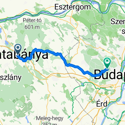
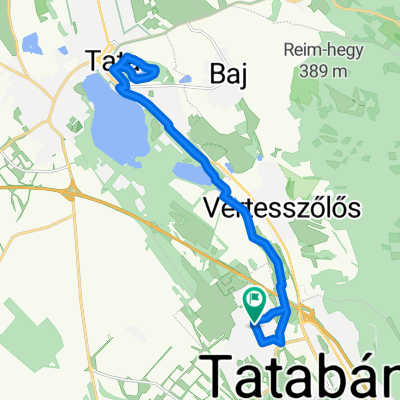
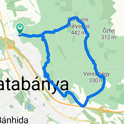
Tatabánya-Bajna-Péliföldszentkereszt-Tardos-Tata
A cycling route starting in Tatabánya, Komárom-Esztergom, Hungary.
Overview
About this route
Tatabányai vasútállomásról indulva, a Gerecse déli oldalán: Tarján, Bajna, Nagysáp érintésével Péliföldszentkeresztnél át a Gerecsén, majd a Duna mellett Lábatlan-Süttő. Azután újra a Gerecsén keresztül Tardos, Agostyán, majd Tata és a vasútállomás.
- -:--
- Duration
- 76.7 km
- Distance
- 685 m
- Ascent
- 704 m
- Descent
- ---
- Avg. speed
- ---
- Max. altitude

Route quality
Waytypes & surfaces along the route
Waytypes
Quiet road
10 km
(13 %)
Track
3.1 km
(4 %)
Surfaces
Paved
26.1 km
(34 %)
Unpaved
3.1 km
(4 %)
Asphalt
26.1 km
(34 %)
Unpaved (undefined)
3.1 km
(4 %)
Undefined
47.5 km
(62 %)
Continue with Bikemap
Use, edit, or download this cycling route
You would like to ride Tatabánya-Bajna-Péliföldszentkereszt-Tardos-Tata or customize it for your own trip? Here is what you can do with this Bikemap route:
Free features
- Save this route as favorite or in collections
- Copy & plan your own version of this route
- Sync your route with Garmin or Wahoo
Premium features
Free trial for 3 days, or one-time payment. More about Bikemap Premium.
- Navigate this route on iOS & Android
- Export a GPX / KML file of this route
- Create your custom printout (try it for free)
- Download this route for offline navigation
Discover more Premium features.
Get Bikemap PremiumFrom our community
Other popular routes starting in Tatabánya
 által ér trip
- Distance
- 22.1 km
- Ascent
- 8 m
- Descent
- 4 m
- Location
- Tatabánya, Komárom-Esztergom, Hungary
 Hadsereg utca, Tatabánya - Hadsereg utca, Tatabánya
- Distance
- 47.3 km
- Ascent
- 136 m
- Descent
- 137 m
- Location
- Tatabánya, Komárom-Esztergom, Hungary
 Gerecse kiskör
- Distance
- 21.7 km
- Ascent
- 576 m
- Descent
- 570 m
- Location
- Tatabánya, Komárom-Esztergom, Hungary
 Koktélbirka
- Distance
- 16.8 km
- Ascent
- 12 m
- Descent
- 94 m
- Location
- Tatabánya, Komárom-Esztergom, Hungary
 Ifjúmunkás utca, Tatabánya - Ifjúmunkás utca, Tatabánya
- Distance
- 29.9 km
- Ascent
- 99 m
- Descent
- 106 m
- Location
- Tatabánya, Komárom-Esztergom, Hungary
 Kerékpár maraton - 5. nap
- Distance
- 56.7 km
- Ascent
- 628 m
- Descent
- 437 m
- Location
- Tatabánya, Komárom-Esztergom, Hungary
 Hadsereg utca, Tatabánya - Hadsereg utca, Tatabánya
- Distance
- 25.1 km
- Ascent
- 144 m
- Descent
- 145 m
- Location
- Tatabánya, Komárom-Esztergom, Hungary
 Tatabánya - Turul kör
- Distance
- 12.5 km
- Ascent
- 508 m
- Descent
- 505 m
- Location
- Tatabánya, Komárom-Esztergom, Hungary
Open it in the app