
1. etapa - sobota 31.5.2014 - cca 90km
A cycling route starting in Tanvald, Liberecký kraj, Czechia.
Overview
About this route
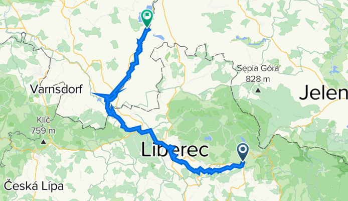
Start: Tanvald
- source of the Nisa - Jablonec - Liberec - Hrádek nad Nisou - Zittau - Finish: Hagenwerder- -:--
- Duration
- 89.9 km
- Distance
- 276 m
- Ascent
- 552 m
- Descent
- ---
- Avg. speed
- ---
- Max. altitude

Route quality
Waytypes & surfaces along the route
Waytypes
Road
24.3 km
(27 %)
Quiet road
18.9 km
(21 %)
Surfaces
Paved
71 km
(79 %)
Unpaved
2.7 km
(3 %)
Asphalt
67.4 km
(75 %)
Paved (undefined)
3.6 km
(4 %)
Continue with Bikemap
Use, edit, or download this cycling route
You would like to ride 1. etapa - sobota 31.5.2014 - cca 90km or customize it for your own trip? Here is what you can do with this Bikemap route:
Free features
- Save this route as favorite or in collections
- Copy & plan your own version of this route
- Split it into stages to create a multi-day tour
- Sync your route with Garmin or Wahoo
Premium features
Free trial for 3 days, or one-time payment. More about Bikemap Premium.
- Navigate this route on iOS & Android
- Export a GPX / KML file of this route
- Create your custom printout (try it for free)
- Download this route for offline navigation
Discover more Premium features.
Get Bikemap PremiumFrom our community
Other popular routes starting in Tanvald
 Rund um das Iser-Gebirge
- Distance
- 76.3 km
- Ascent
- 714 m
- Descent
- 922 m
- Location
- Tanvald, Liberecký kraj, Czechia
 Jizerské hory
- Distance
- 69 km
- Ascent
- 1,252 m
- Descent
- 1,324 m
- Location
- Tanvald, Liberecký kraj, Czechia
 Zlaťák clasic
- Distance
- 83 km
- Ascent
- 1,877 m
- Descent
- 1,877 m
- Location
- Tanvald, Liberecký kraj, Czechia
 Po Jizerských loučkách
- Distance
- 58.6 km
- Ascent
- 901 m
- Descent
- 909 m
- Location
- Tanvald, Liberecký kraj, Czechia
 Tanvald - Železný Brod - Malá Skála - Kopanina - Císařův kámen - Liberec
- Distance
- 68.1 km
- Ascent
- 1,116 m
- Descent
- 1,212 m
- Location
- Tanvald, Liberecký kraj, Czechia
 Tanvald - Jelena Gora
- Distance
- 48 km
- Ascent
- 628 m
- Descent
- 740 m
- Location
- Tanvald, Liberecký kraj, Czechia
 šumburk-semily-kozákov-ž.brod-bozkov-žumburk
- Distance
- 81.4 km
- Ascent
- 1,664 m
- Descent
- 1,529 m
- Location
- Tanvald, Liberecký kraj, Czechia
 Zlaté návrší / Labská bouda (plán na 2.6.2013)
- Distance
- 137.2 km
- Ascent
- 2,395 m
- Descent
- 2,595 m
- Location
- Tanvald, Liberecký kraj, Czechia
Open it in the app