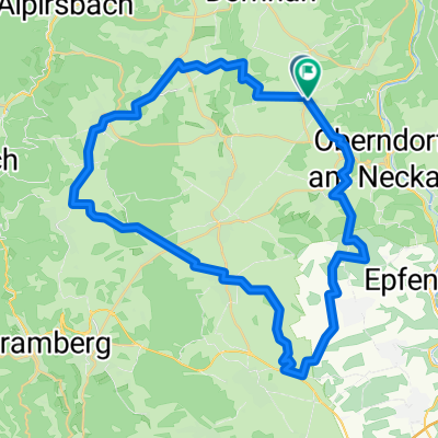
Lindenhof-Dunningen
A cycling route starting in Oberndorf, Baden-Württemberg, Germany.
Overview
About this route
Start auf dem Lindenhof. Beffendorf-Winzeln-Waldmössingen-Heiligenbronn-Seedorf-Dunningen-Seedorf-Waldmössingen-Geigenberg-Beffendorf-Lindenhof.
- -:--
- Duration
- 38.2 km
- Distance
- 210 m
- Ascent
- 211 m
- Descent
- ---
- Avg. speed
- ---
- Avg. speed
Route quality
Waytypes & surfaces along the route
Waytypes
Quiet road
14.4 km
(38 %)
Track
12.6 km
(33 %)
Surfaces
Paved
31.3 km
(82 %)
Unpaved
3.6 km
(10 %)
Asphalt
28.9 km
(75 %)
Gravel
3.6 km
(10 %)
Continue with Bikemap
Use, edit, or download this cycling route
You would like to ride Lindenhof-Dunningen or customize it for your own trip? Here is what you can do with this Bikemap route:
Free features
- Save this route as favorite or in collections
- Copy & plan your own version of this route
- Sync your route with Garmin or Wahoo
Premium features
Free trial for 3 days, or one-time payment. More about Bikemap Premium.
- Navigate this route on iOS & Android
- Export a GPX / KML file of this route
- Create your custom printout (try it for free)
- Download this route for offline navigation
Discover more Premium features.
Get Bikemap PremiumFrom our community
Other popular routes starting in Oberndorf
- Weiden-Freudenstadt-Weiden
- Distance
- 58.1 km
- Ascent
- 868 m
- Descent
- 959 m
- Location
- Oberndorf, Baden-Württemberg, Germany
- Links und rechts vom oberen Neckartal
- Distance
- 54.9 km
- Ascent
- 787 m
- Descent
- 689 m
- Location
- Oberndorf, Baden-Württemberg, Germany
- Lindenhof - Sulz
- Distance
- 25.7 km
- Ascent
- 340 m
- Descent
- 336 m
- Location
- Oberndorf, Baden-Württemberg, Germany
- 3-Täler-Tour
- Distance
- 46.6 km
- Ascent
- 331 m
- Descent
- 332 m
- Location
- Oberndorf, Baden-Württemberg, Germany
- Vatertagstour zur Struthütte
- Distance
- 57.4 km
- Ascent
- 405 m
- Descent
- 417 m
- Location
- Oberndorf, Baden-Württemberg, Germany
- Beff-Alp-Schil-Wolf-Horn-Fohr-Lang-Hardt-Maria-Flöz-Bös-Beff
- Distance
- 104 km
- Ascent
- 948 m
- Descent
- 948 m
- Location
- Oberndorf, Baden-Württemberg, Germany
- Kleine "Flugplatzrunde"
- Distance
- 20.9 km
- Ascent
- 117 m
- Descent
- 112 m
- Location
- Oberndorf, Baden-Württemberg, Germany
- Elsass 4
- Distance
- 80.7 km
- Ascent
- 1,298 m
- Descent
- 1,585 m
- Location
- Oberndorf, Baden-Württemberg, Germany
Open it in the app