

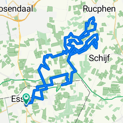
Rondje Halsteren tholen hoogerheide
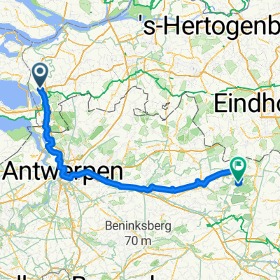
A cycling route starting in Essen, Flemish Region, Belgium.
Overview
About this route
Ride around Halsteren Tholen Hoogerheide
- -:--
- Duration
- 48.4 km
- Distance
- 44 m
- Ascent
- 42 m
- Descent
- ---
- Avg. speed
- ---
- Max. altitude

Continue with Bikemap
Use, edit, or download this cycling route
You would like to ride Rondje Halsteren tholen hoogerheide or customize it for your own trip? Here is what you can do with this Bikemap route:
Free features
- Save this route as favorite or in collections
- Copy & plan your own version of this route
- Sync your route with Garmin or Wahoo
Premium features
Free trial for 3 days, or one-time payment. More about Bikemap Premium.
- Navigate this route on iOS & Android
- Export a GPX / KML file of this route
- Create your custom printout (try it for free)
- Download this route for offline navigation
Discover more Premium features.
Get Bikemap PremiumFrom our community
Other popular routes starting in Essen
 super heroic classic
- Distance
- 111.2 km
- Ascent
- 29 m
- Descent
- 29 m
- Location
- Essen, Flemish Region, Belgium
 Wildert-Willemstad
- Distance
- 87 km
- Ascent
- 24 m
- Descent
- 21 m
- Location
- Essen, Flemish Region, Belgium
 20091213 toertocht Essen
- Distance
- 43.4 km
- Ascent
- 53 m
- Descent
- 51 m
- Location
- Essen, Flemish Region, Belgium
 Bergen op Zoom - Lommel 124 km
- Distance
- 124.7 km
- Ascent
- 273 m
- Descent
- 225 m
- Location
- Essen, Flemish Region, Belgium
 Nieuwmoer-Loenhout-Meer-Meerle-Minderhout-Wuustwezel-Gooreind-Wildert_110km
- Distance
- 110.7 km
- Ascent
- 62 m
- Descent
- 63 m
- Location
- Essen, Flemish Region, Belgium
 Bergen o.Z. - Domburg - Bergen o.Z. 2
- Distance
- 212.4 km
- Ascent
- 51 m
- Descent
- 46 m
- Location
- Essen, Flemish Region, Belgium
 Loenhout-St.Job_63km
- Distance
- 63.3 km
- Ascent
- 41 m
- Descent
- 42 m
- Location
- Essen, Flemish Region, Belgium
 Rondje Bergen op Zoom - Tholen
- Distance
- 39.5 km
- Ascent
- 45 m
- Descent
- 47 m
- Location
- Essen, Flemish Region, Belgium
Open it in the app