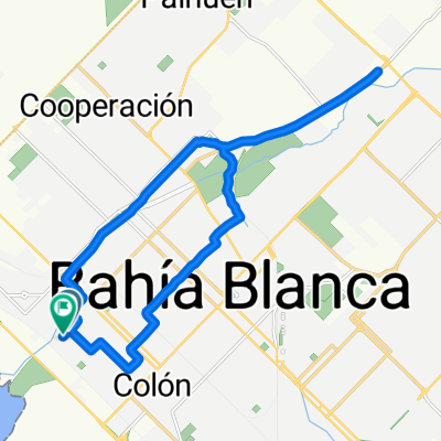
Calderón - Corti - Canessa por tierra con señales
A cycling route starting in Bahía Blanca, Buenos Aires, Argentina.
Overview
About this route
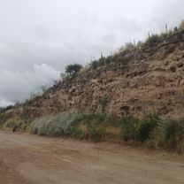
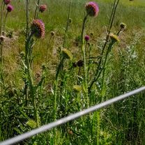
With illustrative photos of the places and detours, to make the way easier
- -:--
- Duration
- 79.6 km
- Distance
- 145 m
- Ascent
- 147 m
- Descent
- ---
- Avg. speed
- ---
- Max. altitude
Route quality
Waytypes & surfaces along the route
Waytypes
- Quiet road - 66.9 km - (84 %) 
- Road - 4 km - (5 %) 
Surfaces
Paved
23.9 km
(30 %)
Unpaved
47 km
(59 %)
- Unpaved (undefined) - 44.6 km - (56 %) 
- Asphalt - 20.7 km - (26 %) 
Continue with Bikemap
Use, edit, or download this cycling route
You would like to ride Calderón - Corti - Canessa por tierra con señales or customize it for your own trip? Here is what you can do with this Bikemap route:
Free features
- Save this route as favorite or in collections
- Copy & plan your own version of this route
- Sync your route with Garmin or Wahoo
Premium features
Free trial for 3 days, or one-time payment. More about Bikemap Premium.
- Navigate this route on iOS & Android
- Export a GPX / KML file of this route
- Create your custom printout (try it for free)
- Download this route for offline navigation
Discover more Premium features.
Get Bikemap PremiumFrom our community
Other popular routes starting in Bahía Blanca
 Bahía blanca - pehuen co Bahía blanca - pehuen co- Distance
- 82.1 km
- Ascent
- 466 m
- Descent
- 481 m
- Location
- Bahía Blanca, Buenos Aires, Argentina
 
 Bahía Blanca a San Andrés de la sierra(carrindanga/camino prov/ruta 76) Bahía Blanca a San Andrés de la sierra(carrindanga/camino prov/ruta 76)- Distance
- 108.6 km
- Ascent
- 521 m
- Descent
- 146 m
- Location
- Bahía Blanca, Buenos Aires, Argentina
 
 Vuelta Nueva Roma Vuelta Nueva Roma- Distance
- 92.9 km
- Ascent
- 102 m
- Descent
- 92 m
- Location
- Bahía Blanca, Buenos Aires, Argentina
 
 Calderón - Corti - Canessa por tierra con señales Calderón - Corti - Canessa por tierra con señales- Distance
- 79.6 km
- Ascent
- 145 m
- Descent
- 147 m
- Location
- Bahía Blanca, Buenos Aires, Argentina
 
 Ría por el salitral Ría por el salitral- Distance
- 100.1 km
- Ascent
- 161 m
- Descent
- 166 m
- Location
- Bahía Blanca, Buenos Aires, Argentina
 
 BAHIA BLANCA: ALTOS DEL ÑATO BAHIA BLANCA: ALTOS DEL ÑATO- Distance
- 12.7 km
- Ascent
- 72 m
- Descent
- 72 m
- Location
- Bahía Blanca, Buenos Aires, Argentina
 
 Bahía - Pehuen-Co Bahía - Pehuen-Co- Distance
- 88.5 km
- Ascent
- 125 m
- Descent
- 142 m
- Location
- Bahía Blanca, Buenos Aires, Argentina
 
 del CAÑON a SIERRA DE LA VENTANA del CAÑON a SIERRA DE LA VENTANA- Distance
- 88.4 km
- Ascent
- 405 m
- Descent
- 190 m
- Location
- Bahía Blanca, Buenos Aires, Argentina
 
Open it in the app


