

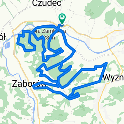
Czudec- Sołonka
A cycling route starting in Czudec, Subcarpathian Voivodeship, Poland.
Overview
About this route
Route to the Sołanka climb. 3 km at about 5-6%. Road condition is good, light traffic.
- -:--
- Duration
- 14.5 km
- Distance
- 327 m
- Ascent
- 145 m
- Descent
- ---
- Avg. speed
- ---
- Max. altitude
Route quality
Waytypes & surfaces along the route
Waytypes
Quiet road
4.5 km
(31 %)
Road
4.4 km
(30 %)
Surfaces
Paved
12.4 km
(85 %)
Unpaved
1 km
(7 %)
Asphalt
12.4 km
(85 %)
Gravel
1 km
(7 %)
Undefined
1.2 km
(8 %)
Continue with Bikemap
Use, edit, or download this cycling route
You would like to ride Czudec- Sołonka or customize it for your own trip? Here is what you can do with this Bikemap route:
Free features
- Save this route as favorite or in collections
- Copy & plan your own version of this route
- Sync your route with Garmin or Wahoo
Premium features
Free trial for 3 days, or one-time payment. More about Bikemap Premium.
- Navigate this route on iOS & Android
- Export a GPX / KML file of this route
- Create your custom printout (try it for free)
- Download this route for offline navigation
Discover more Premium features.
Get Bikemap PremiumFrom our community
Other popular routes starting in Czudec
 jaazzzda
- Distance
- 74.8 km
- Ascent
- 663 m
- Descent
- 663 m
- Location
- Czudec, Subcarpathian Voivodeship, Poland
 Czudec- Sołonka
- Distance
- 14.5 km
- Ascent
- 327 m
- Descent
- 145 m
- Location
- Czudec, Subcarpathian Voivodeship, Poland
 Okolice Rzeszowa i Strzyżowa
- Distance
- 369 km
- Ascent
- 5,131 m
- Descent
- 5,142 m
- Location
- Czudec, Subcarpathian Voivodeship, Poland
 Przejazd przez działy
- Distance
- 8.5 km
- Ascent
- 220 m
- Descent
- 220 m
- Location
- Czudec, Subcarpathian Voivodeship, Poland
 MTB Czudec 2019
- Distance
- 25.5 km
- Ascent
- 996 m
- Descent
- 988 m
- Location
- Czudec, Subcarpathian Voivodeship, Poland
 wycieczka w czasah chmar komarów i bąków
- Distance
- 73 km
- Ascent
- 828 m
- Descent
- 829 m
- Location
- Czudec, Subcarpathian Voivodeship, Poland
 Las w Niechobrzu 2
- Distance
- 11.2 km
- Ascent
- 152 m
- Descent
- 114 m
- Location
- Czudec, Subcarpathian Voivodeship, Poland
 Szarych Szeregów 2, Czudec do Szarych Szeregów 2, Czudec
- Distance
- 27.1 km
- Ascent
- 918 m
- Descent
- 918 m
- Location
- Czudec, Subcarpathian Voivodeship, Poland
Open it in the app