

Vzpon v Nebesa
A cycling route starting in Šentrupert na Dolenjskem, Občina Šentrupert, Slovenia.
Overview
About this route
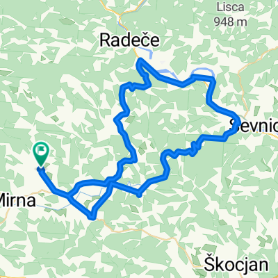
Šentrupert – Prelesje – Rakovnik – Slovenska vas – Brinje – Šentrupert – Draga pri Šentrupertu – Hom - Nebesa v dolžini 12,5 km. Višinska razlika 310 m.
- -:--
- Duration
- 12.4 km
- Distance
- 368 m
- Ascent
- 50 m
- Descent
- ---
- Avg. speed
- ---
- Max. altitude
Route quality
Waytypes & surfaces along the route
Waytypes
Road
10.2 km
(82 %)
Track
0.4 km
(3 %)
Undefined
1.9 km
(15 %)
Surfaces
Paved
4.8 km
(39 %)
Asphalt
4.5 km
(36 %)
Paved (undefined)
0.4 km
(3 %)
Undefined
7.6 km
(61 %)
Continue with Bikemap
Use, edit, or download this cycling route
You would like to ride Vzpon v Nebesa or customize it for your own trip? Here is what you can do with this Bikemap route:
Free features
- Save this route as favorite or in collections
- Copy & plan your own version of this route
- Sync your route with Garmin or Wahoo
Premium features
Free trial for 3 days, or one-time payment. More about Bikemap Premium.
- Navigate this route on iOS & Android
- Export a GPX / KML file of this route
- Create your custom printout (try it for free)
- Download this route for offline navigation
Discover more Premium features.
Get Bikemap PremiumFrom our community
Other popular routes starting in Šentrupert na Dolenjskem
 G2: Litija - Šentrupert
- Distance
- 31.5 km
- Ascent
- 738 m
- Descent
- 782 m
- Location
- Šentrupert na Dolenjskem, Občina Šentrupert, Slovenia
 G10: Čez drn in strm preko Nebes
- Distance
- 36.6 km
- Ascent
- 811 m
- Descent
- 811 m
- Location
- Šentrupert na Dolenjskem, Občina Šentrupert, Slovenia
 Šentrupert - Bela rajina
- Distance
- 161.4 km
- Ascent
- 1,712 m
- Descent
- 1,721 m
- Location
- Šentrupert na Dolenjskem, Občina Šentrupert, Slovenia
 G10: Čez drn in strm preko Nebes
- Distance
- 36.6 km
- Ascent
- 807 m
- Descent
- 810 m
- Location
- Šentrupert na Dolenjskem, Občina Šentrupert, Slovenia
 4x 2turna
- Distance
- 139.7 km
- Ascent
- 1,790 m
- Descent
- 1,790 m
- Location
- Šentrupert na Dolenjskem, Občina Šentrupert, Slovenia
 Cvičkova ruta iz Šentruperta v2
- Distance
- 60.4 km
- Ascent
- 644 m
- Descent
- 645 m
- Location
- Šentrupert na Dolenjskem, Občina Šentrupert, Slovenia
 Grozdetova kolesarska pot
- Distance
- 67.5 km
- Ascent
- 778 m
- Descent
- 778 m
- Location
- Šentrupert na Dolenjskem, Občina Šentrupert, Slovenia
 Cvičkova ruta iz Šentruperta
- Distance
- 60.5 km
- Ascent
- 692 m
- Descent
- 692 m
- Location
- Šentrupert na Dolenjskem, Občina Šentrupert, Slovenia
Open it in the app