

6 Pitigliano - Manciano
A cycling route starting in Sorano, Tuscany, Italy.
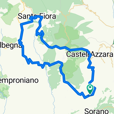
Overview
About this route
Today we ride through the quiet, beautiful tuff landscape with constant ups and downs. The diverse traces of the Etruscans accompany us throughout the entire route. After the charming little village of Sovana, we pass magnificent Etruscan tombs (and may take a quick peek inside) and after some elevation gain we reach the warm springs of Saturnia, which are worth a bath in any weather. A small waterfall has created travertine-like pools with warm water, where you can bathe for free. There are 2 long but never too steep climbs to tackle, summing up to almost 1,000 meters of elevation gain over the day. At the end we reach the town of Manciano, which, unlike the previous ones, is unspectacular. But it has a nice character and one of the best trattorias I know in Tuscany. And that’s exactly where we’ll go, well deserved, after the ride!
- -:--
- Duration
- 54.2 km
- Distance
- 981 m
- Ascent
- 953 m
- Descent
- ---
- Avg. speed
- 501 m
- Max. altitude

Route quality
Waytypes & surfaces along the route
Waytypes
Quiet road
10.3 km
(19 %)
Road
3.8 km
(7 %)
Surfaces
Paved
50.9 km
(94 %)
Unpaved
0.5 km
(1 %)
Asphalt
50.4 km
(93 %)
Concrete
0.5 km
(1 %)
Continue with Bikemap
Use, edit, or download this cycling route
You would like to ride 6 Pitigliano - Manciano or customize it for your own trip? Here is what you can do with this Bikemap route:
Free features
- Save this route as favorite or in collections
- Copy & plan your own version of this route
- Sync your route with Garmin or Wahoo
Premium features
Free trial for 3 days, or one-time payment. More about Bikemap Premium.
- Navigate this route on iOS & Android
- Export a GPX / KML file of this route
- Create your custom printout (try it for free)
- Download this route for offline navigation
Discover more Premium features.
Get Bikemap PremiumFrom our community
Other popular routes starting in Sorano
 Kleine Runde um Poderetto
- Distance
- 43.5 km
- Ascent
- 990 m
- Descent
- 974 m
- Location
- Sorano, Tuscany, Italy
 Poderetto - Elmo - Sorano - Pitigliano - Sovana - Poderetto
- Distance
- 36.1 km
- Ascent
- 752 m
- Descent
- 883 m
- Location
- Sorano, Tuscany, Italy
 7A Pitigliano - Manciano - Capalbio - Orbetello
- Distance
- 75.3 km
- Ascent
- 818 m
- Descent
- 1,176 m
- Location
- Sorano, Tuscany, Italy
 Poderetto - Selvena - Sta. Fiora - Monte Amiata - Abbadia S. Salvatore - Piancastagnaio - Selvena - Poderetto
- Distance
- 81.9 km
- Ascent
- 2,366 m
- Descent
- 2,158 m
- Location
- Sorano, Tuscany, Italy
 Elmo_SFiora_Elmo
- Distance
- 65 km
- Ascent
- 1,719 m
- Descent
- 1,497 m
- Location
- Sorano, Tuscany, Italy
 6 Pitigliano - Manciano
- Distance
- 54.2 km
- Ascent
- 981 m
- Descent
- 953 m
- Location
- Sorano, Tuscany, Italy
 8 Sorano-Manciano BICI
- Distance
- 42.6 km
- Ascent
- 984 m
- Descent
- 964 m
- Location
- Sorano, Tuscany, Italy
 SORANO-SOVANA
- Distance
- 9.6 km
- Ascent
- 148 m
- Descent
- 245 m
- Location
- Sorano, Tuscany, Italy
Open it in the app