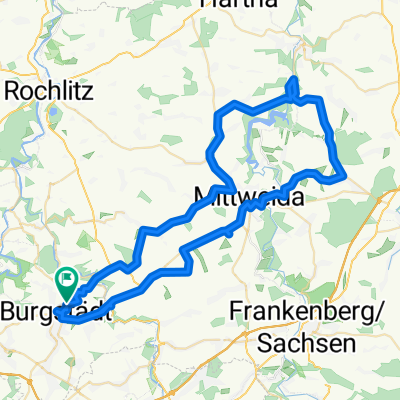
WVB Burgstädt _ Krumbach _ Altmittweida _Claußnitz
A cycling route starting in Burgstädt, Saxony, Germany.
Overview
About this route
Tour towards the Zschopau Valley with beautiful views of the Ore Mountains near the Sonnenland Park. Opportunity to stop at the Wasserschänke Krumbach tavern. The route to Altmittweid is quite hilly.
- -:--
- Duration
- 48 km
- Distance
- 362 m
- Ascent
- 359 m
- Descent
- ---
- Avg. speed
- ---
- Max. altitude
Route quality
Waytypes & surfaces along the route
Waytypes
Quiet road
20.2 km
(42 %)
Road
13.4 km
(28 %)
Surfaces
Paved
24 km
(50 %)
Unpaved
3.8 km
(8 %)
Asphalt
20.2 km
(42 %)
Paved (undefined)
3.8 km
(8 %)
Route highlights
Points of interest along the route
Point of interest after 17.2 km
Blick vom Sonnenlandpark nach Frankenberg
Point of interest after 19.8 km
das Zschopautal bei Frankenberg
Point of interest after 20.5 km
Schilfteich
Point of interest after 21.9 km
Zschopaubrücke an der Fischerschänke
Point of interest after 23.5 km
Zschopautalweg
Point of interest after 24.4 km
Fähre Anna
Point of interest after 24.5 km
Wasserschänke Krumbach
Point of interest after 30 km
Point of interest after 42.7 km
Gedenkstein für Gustav Friedrich Großer am ehemaligen Gromastandort
Continue with Bikemap
Use, edit, or download this cycling route
You would like to ride WVB Burgstädt _ Krumbach _ Altmittweida _Claußnitz or customize it for your own trip? Here is what you can do with this Bikemap route:
Free features
- Save this route as favorite or in collections
- Copy & plan your own version of this route
- Sync your route with Garmin or Wahoo
Premium features
Free trial for 3 days, or one-time payment. More about Bikemap Premium.
- Navigate this route on iOS & Android
- Export a GPX / KML file of this route
- Create your custom printout (try it for free)
- Download this route for offline navigation
Discover more Premium features.
Get Bikemap PremiumFrom our community
Other popular routes starting in Burgstädt
- WVB Radtour Burgstädt - Klaffenbach -Burgstädt
- Distance
- 54.9 km
- Ascent
- 366 m
- Descent
- 356 m
- Location
- Burgstädt, Saxony, Germany
- Mulderadweg - Vereinigte Mulde
- Distance
- 163 km
- Ascent
- 898 m
- Descent
- 641 m
- Location
- Burgstädt, Saxony, Germany
- WVB Burgstädt - Lugau und zurück
- Distance
- 58.2 km
- Ascent
- 352 m
- Descent
- 362 m
- Location
- Burgstädt, Saxony, Germany
- WVB Burgstädt Altenburg und zurück
- Distance
- 68.9 km
- Ascent
- 459 m
- Descent
- 459 m
- Location
- Burgstädt, Saxony, Germany
- Burgstädt - Rochlitz zwischen Mulde und Bahnlinie
- Distance
- 44.4 km
- Ascent
- 395 m
- Descent
- 395 m
- Location
- Burgstädt, Saxony, Germany
- Radweg Rund um die Rochsburg
- Distance
- 35.2 km
- Ascent
- 370 m
- Descent
- 370 m
- Location
- Burgstädt, Saxony, Germany
- Von Burgstädt über Claußnitz ins Wieder- und ins Chemnitztal
- Distance
- 36 km
- Ascent
- 299 m
- Descent
- 299 m
- Location
- Burgstädt, Saxony, Germany
- WVB von Burgstädt durchs Limbacher Land und zurück
- Distance
- 38.7 km
- Ascent
- 300 m
- Descent
- 314 m
- Location
- Burgstädt, Saxony, Germany
Open it in the app