
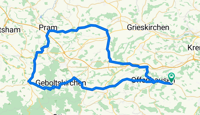
Rennrad - Hausruck Wendling - 68km
A cycling route starting in Pennewang, Upper Austria, Austria.
Overview
About this route
Wilhelmsberg-Affnang-Geboltskirchen-Eberschwang-Geiersberg-Pram-Wendling-Roith-Aistersheim-Offenhausen
- -:--
- Duration
- 68.5 km
- Distance
- 598 m
- Ascent
- 597 m
- Descent
- ---
- Avg. speed
- ---
- Avg. speed
Route quality
Waytypes & surfaces along the route
Waytypes
Busy road
58.6 km
(85 %)
Quiet road
5.1 km
(7 %)
Surfaces
Paved
14.4 km
(21 %)
Asphalt
14.4 km
(21 %)
Undefined
54.1 km
(79 %)
Continue with Bikemap
Use, edit, or download this cycling route
You would like to ride Rennrad - Hausruck Wendling - 68km or customize it for your own trip? Here is what you can do with this Bikemap route:
Free features
- Save this route as favorite or in collections
- Copy & plan your own version of this route
- Sync your route with Garmin or Wahoo
Premium features
Free trial for 3 days, or one-time payment. More about Bikemap Premium.
- Navigate this route on iOS & Android
- Export a GPX / KML file of this route
- Create your custom printout (try it for free)
- Download this route for offline navigation
Discover more Premium features.
Get Bikemap PremiumFrom our community
Other popular routes starting in Pennewang
 Pennewang - R6 Lambach - Oberndorf bei Schwanenstadt - Niederthalheim - Pennewang
- Distance
- 42 km
- Ascent
- 475 m
- Descent
- 480 m
- Location
- Pennewang, Upper Austria, Austria
 Eberstalzell-Vorchdorf
- Distance
- 54.8 km
- Ascent
- 248 m
- Descent
- 248 m
- Location
- Pennewang, Upper Austria, Austria
 18.10.2015
- Distance
- 10.6 km
- Ascent
- 208 m
- Descent
- 216 m
- Location
- Pennewang, Upper Austria, Austria
 Rennrad - Hausruck Wendling - 68km
- Distance
- 68.5 km
- Ascent
- 598 m
- Descent
- 597 m
- Location
- Pennewang, Upper Austria, Austria
 Felling 14 Pennewang - Pitzenberg Hendlbraterei Gamper
- Distance
- 21.1 km
- Ascent
- 243 m
- Descent
- 277 m
- Location
- Pennewang, Upper Austria, Austria
 Oberfils 5 nach Oberfils 5
- Distance
- 85 km
- Ascent
- 151 m
- Descent
- 204 m
- Location
- Pennewang, Upper Austria, Austria
 OBK Umfahrung Entenstein
- Distance
- 32 km
- Ascent
- 309 m
- Descent
- 314 m
- Location
- Pennewang, Upper Austria, Austria
 Julia
Julia- Distance
- 253 km
- Ascent
- 9,020 m
- Descent
- 9,052 m
- Location
- Pennewang, Upper Austria, Austria
Open it in the app