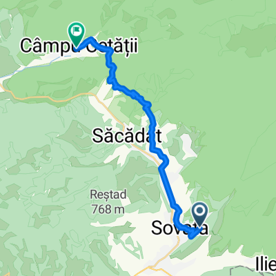
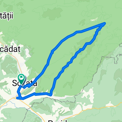
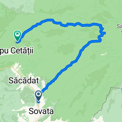
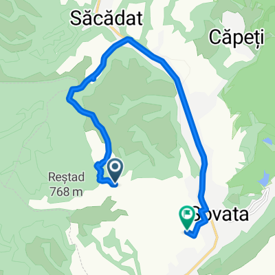
Erdély - rövidített - kis utakon
A cycling route starting in Sovata, Judeţul Mureş, Romania.
Overview
About this route
túraterv
(cloned from route 2531640) (cloned from route 2655651)- -:--
- Duration
- 690.9 km
- Distance
- 2,736 m
- Ascent
- 2,515 m
- Descent
- ---
- Avg. speed
- ---
- Avg. speed
Route quality
Waytypes & surfaces along the route
Waytypes
Busy road
508.9 km
(74 %)
Quiet road
65.7 km
(10 %)
Surfaces
Paved
561.7 km
(81 %)
Unpaved
92.5 km
(13 %)
Asphalt
555.9 km
(80 %)
Gravel
62.9 km
(9 %)
Route highlights
Points of interest along the route
Point of interest after 9.3 km
Korond http://www.erdely-szep.hu/Korond%20es%20Szovata/index.html
Point of interest after 212.5 km
Na itt nem biztos, hogy van út! :D
Point of interest after 234 km
http://muhos.ro/
Point of interest after 279.7 km
Madarasi-Hargita - 1801 m http://www.erdely-szep.hu/Madarasi-Hargita%203/index.html
Point of interest after 296.1 km
Zeteváralja http://www.femina.hu/utazas/legszebb_helyek_szallasok_erdelyben
Point of interest after 383 km
Marosvásárhely opció: Hargita IC - kerékpár -> BP.
Point of interest after 405.7 km
Kolozsvár opció: Hargita IC - kerékpár -> Bp.
Point of interest after 405.7 km
Torockó
Point of interest after 405.7 km
Tordatúr - sziklák
Point of interest after 405.7 km
Tordai hasadék
Point of interest after 405.7 km
Torda - sóbánya
Point of interest after 406.1 km
Déva (vár)
Point of interest after 406.1 km
Medgyes (+ vár)
Point of interest after 406.1 km
Gyulafehérvár
Point of interest after 413.4 km
Patru Hotare-tó
Point of interest after 559.3 km
Almási barlang http://www.utazzerdelybe.hu/almasi-barlang.html
Point of interest after 640.3 km
Uzonkafürdő http://hu.wikipedia.org/wiki/Uzonkaf%C3%BCrd%C5%91
Point of interest after 666.8 km
Tusnád http://www.sohaztur.ro/tusnad.htm
Point of interest after 689.5 km
Hargita - 1400 m
Continue with Bikemap
Use, edit, or download this cycling route
You would like to ride Erdély - rövidített - kis utakon or customize it for your own trip? Here is what you can do with this Bikemap route:
Free features
- Save this route as favorite or in collections
- Copy & plan your own version of this route
- Sync your route with Garmin or Wahoo
Premium features
Free trial for 3 days, or one-time payment. More about Bikemap Premium.
- Navigate this route on iOS & Android
- Export a GPX / KML file of this route
- Create your custom printout (try it for free)
- Download this route for offline navigation
Discover more Premium features.
Get Bikemap PremiumFrom our community
Other popular routes starting in Sovata
- Cserepeskő
- Distance
- 37.4 km
- Ascent
- 1,097 m
- Descent
- 1,082 m
- Location
- Sovata, Judeţul Mureş, Romania
- Sovata-MiercureaNirajului-Tampa-TarguMures
- Distance
- 44.3 km
- Ascent
- 329 m
- Descent
- 395 m
- Location
- Sovata, Judeţul Mureş, Romania
- sovata-eremitu-matrici-sovata
- Distance
- 69.3 km
- Ascent
- 579 m
- Descent
- 596 m
- Location
- Sovata, Judeţul Mureş, Romania
- Strada Izvorului 6, Sovata to Strada Izvorului 5, Sovata
- Distance
- 18.5 km
- Ascent
- 215 m
- Descent
- 217 m
- Location
- Sovata, Judeţul Mureş, Romania
- Nyugodt útvonal
- Distance
- 21.6 km
- Ascent
- 430 m
- Descent
- 471 m
- Location
- Sovata, Judeţul Mureş, Romania
- Rusalii 2016 - var 2 - zi 2
- Distance
- 144.5 km
- Ascent
- 1,879 m
- Descent
- 1,991 m
- Location
- Sovata, Judeţul Mureş, Romania
- Bekecs
- Distance
- 33.3 km
- Ascent
- 759 m
- Descent
- 756 m
- Location
- Sovata, Judeţul Mureş, Romania
- Sovata - M. Nirajului - Tg Mureș - Eremitu (>) (RS200)
- Distance
- 114.2 km
- Ascent
- 897 m
- Descent
- 884 m
- Location
- Sovata, Judeţul Mureş, Romania
Open it in the app