

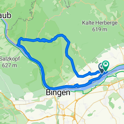
Mittelheim, 7 Wegweiser, Kalte Herberge, Hallgartner Zange, Mittelheim
A cycling route starting in Oestrich-Winkel, Rhineland-Palatinate, Germany.
Overview
About this route
Starting point at the corner of Gänsbaumstraße/Ägidiusstraße
Vineyards towards the Winkler Waldäcker Anspach 7 signposts Rhine Heights Trail Kalte Herberge Hallgartner Zange ... downhill home, maybe enjoy a Schorle at the Mack winery ;-)- -:--
- Duration
- 21.1 km
- Distance
- 535 m
- Ascent
- 535 m
- Descent
- ---
- Avg. speed
- ---
- Max. altitude
Route quality
Waytypes & surfaces along the route
Waytypes
Track
19.4 km
(92 %)
Quiet road
0.8 km
(4 %)
Surfaces
Paved
7.4 km
(35 %)
Unpaved
13.3 km
(63 %)
Gravel
10.8 km
(51 %)
Asphalt
6.3 km
(30 %)
Route highlights
Points of interest along the route
Point of interest after 14.2 km
Hallgartner Zange
Continue with Bikemap
Use, edit, or download this cycling route
You would like to ride Mittelheim, 7 Wegweiser, Kalte Herberge, Hallgartner Zange, Mittelheim or customize it for your own trip? Here is what you can do with this Bikemap route:
Free features
- Save this route as favorite or in collections
- Copy & plan your own version of this route
- Sync your route with Garmin or Wahoo
Premium features
Free trial for 3 days, or one-time payment. More about Bikemap Premium.
- Navigate this route on iOS & Android
- Export a GPX / KML file of this route
- Create your custom printout (try it for free)
- Download this route for offline navigation
Discover more Premium features.
Get Bikemap PremiumFrom our community
Other popular routes starting in Oestrich-Winkel
 Rheingau retour
- Distance
- 17.9 km
- Ascent
- 55 m
- Descent
- 72 m
- Location
- Oestrich-Winkel, Rhineland-Palatinate, Germany
 Mittelheim, 7 Wegweiser, Kalte Herberge, Hallgartner Zange, Mittelheim
- Distance
- 21.1 km
- Ascent
- 535 m
- Descent
- 535 m
- Location
- Oestrich-Winkel, Rhineland-Palatinate, Germany
 Vordertaunus-Wispertal
- Distance
- 57.3 km
- Ascent
- 735 m
- Descent
- 735 m
- Location
- Oestrich-Winkel, Rhineland-Palatinate, Germany
 Mittelheim_Lenneberg_Schwabenheim
- Distance
- 48.8 km
- Ascent
- 184 m
- Descent
- 187 m
- Location
- Oestrich-Winkel, Rhineland-Palatinate, Germany
 Rheingau 1
- Distance
- 33 km
- Ascent
- 182 m
- Descent
- 182 m
- Location
- Oestrich-Winkel, Rhineland-Palatinate, Germany
 Monte Presso
- Distance
- 47 km
- Ascent
- 599 m
- Descent
- 598 m
- Location
- Oestrich-Winkel, Rhineland-Palatinate, Germany
 Sonntagsrunde mit Kathrin
- Distance
- 20.3 km
- Ascent
- 300 m
- Descent
- 300 m
- Location
- Oestrich-Winkel, Rhineland-Palatinate, Germany
 Fugplatz Finthen
- Distance
- 38 km
- Ascent
- 187 m
- Descent
- 188 m
- Location
- Oestrich-Winkel, Rhineland-Palatinate, Germany
Open it in the app