

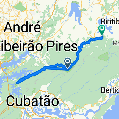
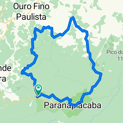
Paranapiacaba - Quatinga via Taquaruçu
A cycling route starting in Rio Grande da Serra, São Paulo, Brazil.
Overview
About this route
Via singletrack after the little creek
- -:--
- Duration
- 38.5 km
- Distance
- 446 m
- Ascent
- 452 m
- Descent
- ---
- Avg. speed
- ---
- Max. altitude
Route quality
Waytypes & surfaces along the route
Waytypes
Road
25.4 km
(66 %)
Quiet road
12.7 km
(33 %)
Path
0.4 km
(1 %)
Surfaces
Paved
0.4 km
(1 %)
Unpaved
36.6 km
(95 %)
Ground
33.1 km
(86 %)
Unpaved (undefined)
3.5 km
(9 %)
Route highlights
Points of interest along the route
Point of interest after 14.3 km
Quatinga - Mercado e lanchonetes
Point of interest after 32.5 km
Bar das Tortas
Continue with Bikemap
Use, edit, or download this cycling route
You would like to ride Paranapiacaba - Quatinga via Taquaruçu or customize it for your own trip? Here is what you can do with this Bikemap route:
Free features
- Save this route as favorite or in collections
- Copy & plan your own version of this route
- Sync your route with Garmin or Wahoo
Premium features
Free trial for 3 days, or one-time payment. More about Bikemap Premium.
- Navigate this route on iOS & Android
- Export a GPX / KML file of this route
- Create your custom printout (try it for free)
- Download this route for offline navigation
Discover more Premium features.
Get Bikemap PremiumFrom our community
Other popular routes starting in Rio Grande da Serra
 RGSerra trilha cachorro louco
- Distance
- 26.8 km
- Ascent
- 382 m
- Descent
- 389 m
- Location
- Rio Grande da Serra, São Paulo, Brazil
 Trilha Porteira Preta, Parte Baixa
- Distance
- 30.4 km
- Ascent
- 398 m
- Descent
- 396 m
- Location
- Rio Grande da Serra, São Paulo, Brazil
 Terra 56KM Paranapiacaba
- Distance
- 58 km
- Ascent
- 546 m
- Descent
- 548 m
- Location
- Rio Grande da Serra, São Paulo, Brazil
 CAMINHO DO SAL (Mogi das Cruzes, Paranapiacaba, Riacho Grande)
- Distance
- 68.2 km
- Ascent
- 494 m
- Descent
- 522 m
- Location
- Rio Grande da Serra, São Paulo, Brazil
 Trilha em Paranapiacaba
- Distance
- 34.2 km
- Ascent
- 406 m
- Descent
- 406 m
- Location
- Rio Grande da Serra, São Paulo, Brazil
 Paranapiacaba x Magic City x Taquarussu x Paranapiacaba
- Distance
- 41.3 km
- Ascent
- 619 m
- Descent
- 617 m
- Location
- Rio Grande da Serra, São Paulo, Brazil
 Trilha da Torta + Sabão
- Distance
- 30 km
- Ascent
- 411 m
- Descent
- 411 m
- Location
- Rio Grande da Serra, São Paulo, Brazil
 Rio Grande da Serra-Paranapiacaba
- Distance
- 12.9 km
- Ascent
- 277 m
- Descent
- 200 m
- Location
- Rio Grande da Serra, São Paulo, Brazil
Open it in the app