

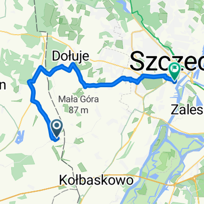
Barnisław -Loeknitz
A cycling route starting in Kołbaskowo, West Pomeranian Voivodeship, Poland.
Overview
About this route
Route along the border roads of Germany to Loeknitz
- -:--
- Duration
- 42.5 km
- Distance
- 106 m
- Ascent
- 106 m
- Descent
- ---
- Avg. speed
- ---
- Max. altitude
Route quality
Waytypes & surfaces along the route
Waytypes
Quiet road
20 km
(47 %)
Road
14.9 km
(35 %)
Surfaces
Paved
33.2 km
(78 %)
Unpaved
2.6 km
(6 %)
Asphalt
30.2 km
(71 %)
Concrete
2.6 km
(6 %)
Route highlights
Points of interest along the route
Point of interest after 18.8 km
1000 letni dąb/ 1000 oak
Continue with Bikemap
Use, edit, or download this cycling route
You would like to ride Barnisław -Loeknitz or customize it for your own trip? Here is what you can do with this Bikemap route:
Free features
- Save this route as favorite or in collections
- Copy & plan your own version of this route
- Sync your route with Garmin or Wahoo
Premium features
Free trial for 3 days, or one-time payment. More about Bikemap Premium.
- Navigate this route on iOS & Android
- Export a GPX / KML file of this route
- Create your custom printout (try it for free)
- Download this route for offline navigation
Discover more Premium features.
Get Bikemap PremiumFrom our community
Other popular routes starting in Kołbaskowo
 2011-06-05 Moczyły
- Distance
- 12 km
- Ascent
- 4 m
- Descent
- 4 m
- Location
- Kołbaskowo, West Pomeranian Voivodeship, Poland
 Ladenthin do Potulicka 20C
- Distance
- 24.6 km
- Ascent
- 90 m
- Descent
- 172 m
- Location
- Kołbaskowo, West Pomeranian Voivodeship, Poland
 Do jeziora Lebehn
- Distance
- 12.4 km
- Ascent
- 48 m
- Descent
- 49 m
- Location
- Kołbaskowo, West Pomeranian Voivodeship, Poland
 Barnisław -Loeknitz
- Distance
- 42.5 km
- Ascent
- 106 m
- Descent
- 106 m
- Location
- Kołbaskowo, West Pomeranian Voivodeship, Poland
 Penkun
- Distance
- 66.1 km
- Ascent
- 176 m
- Descent
- 176 m
- Location
- Kołbaskowo, West Pomeranian Voivodeship, Poland
 Rosówek - Penkun
- Distance
- 42.1 km
- Ascent
- 126 m
- Descent
- 129 m
- Location
- Kołbaskowo, West Pomeranian Voivodeship, Poland
 Kolboskowo - Chorin am Amtsee
- Distance
- 75 km
- Ascent
- 128 m
- Descent
- 97 m
- Location
- Kołbaskowo, West Pomeranian Voivodeship, Poland
 Trasa do Zielna 13, Gryfino
- Distance
- 7.2 km
- Ascent
- 101 m
- Descent
- 101 m
- Location
- Kołbaskowo, West Pomeranian Voivodeship, Poland
Open it in the app