

La Salada-Valdelinares
A cycling route starting in Barracas, Valencia, Spain.
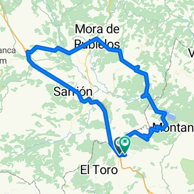
Overview
About this route
Ibilbide lasaia mendialde garaietan zehar
- -:--
- Duration
- 245.2 km
- Distance
- 3,204 m
- Ascent
- 3,204 m
- Descent
- ---
- Avg. speed
- ---
- Max. altitude
Route quality
Waytypes & surfaces along the route
Waytypes
Road
78.5 km
(32 %)
Quiet road
31.9 km
(13 %)
Surfaces
Paved
36.8 km
(15 %)
Unpaved
4.9 km
(2 %)
Asphalt
31.9 km
(13 %)
Paved (undefined)
4.9 km
(2 %)
Continue with Bikemap
Use, edit, or download this cycling route
You would like to ride La Salada-Valdelinares or customize it for your own trip? Here is what you can do with this Bikemap route:
Free features
- Save this route as favorite or in collections
- Copy & plan your own version of this route
- Split it into stages to create a multi-day tour
- Sync your route with Garmin or Wahoo
Premium features
Free trial for 3 days, or one-time payment. More about Bikemap Premium.
- Navigate this route on iOS & Android
- Export a GPX / KML file of this route
- Create your custom printout (try it for free)
- Download this route for offline navigation
Discover more Premium features.
Get Bikemap PremiumFrom our community
Other popular routes starting in Barracas
 3ª ETAPA BARRACAS - SAGUNTO
- Distance
- 88.1 km
- Ascent
- 543 m
- Descent
- 1,526 m
- Location
- Barracas, Valencia, Spain
 Barracas - Manzanera - Barracas
- Distance
- 48.9 km
- Ascent
- 499 m
- Descent
- 520 m
- Location
- Barracas, Valencia, Spain
 La Salada-Valdelinares
- Distance
- 245.2 km
- Ascent
- 3,204 m
- Descent
- 3,204 m
- Location
- Barracas, Valencia, Spain
 Barracas-Alcotas-Manzanera-Albentosa
- Distance
- 42.9 km
- Ascent
- 422 m
- Descent
- 423 m
- Location
- Barracas, Valencia, Spain
 Barracas-Rubielos
- Distance
- 117.7 km
- Ascent
- 1,135 m
- Descent
- 1,083 m
- Location
- Barracas, Valencia, Spain
 Etapa 7.-Barracas-Sagunto2
- Distance
- 66 km
- Ascent
- 87 m
- Descent
- 1,029 m
- Location
- Barracas, Valencia, Spain
 EL TORO-LA SALADA-EL TORO
- Distance
- 30.1 km
- Ascent
- 764 m
- Descent
- 763 m
- Location
- Barracas, Valencia, Spain
 El Toro - El Pozo Junco - Estació Militar
- Distance
- 37.9 km
- Ascent
- 1,107 m
- Descent
- 1,048 m
- Location
- Barracas, Valencia, Spain
Open it in the app