Oberperfuss -Stubaier Gletscher
A cycling route starting in Unterperfuss, Tyrol, Austria.
Overview
About this route
bis zur Talstation....
(cloned from route 2660120)
- -:--
- Duration
- 60 km
- Distance
- 1,287 m
- Ascent
- 413 m
- Descent
- ---
- Avg. speed
- ---
- Avg. speed
Route quality
Waytypes & surfaces along the route
Waytypes
Busy road
46.2 km
(77 %)
Road
7.8 km
(13 %)
Surfaces
Paved
56.7 km
(94 %)
Unpaved
0.2 km
(<1 %)
Asphalt
56.6 km
(94 %)
Gravel
0.1 km
(<1 %)
Continue with Bikemap
Use, edit, or download this cycling route
You would like to ride Oberperfuss -Stubaier Gletscher or customize it for your own trip? Here is what you can do with this Bikemap route:
Free features
- Save this route as favorite or in collections
- Copy & plan your own version of this route
- Sync your route with Garmin or Wahoo
Premium features
Free trial for 3 days, or one-time payment. More about Bikemap Premium.
- Navigate this route on iOS & Android
- Export a GPX / KML file of this route
- Create your custom printout (try it for free)
- Download this route for offline navigation
Discover more Premium features.
Get Bikemap PremiumFrom our community
Other popular routes starting in Unterperfuss
- 6. etappe zirl - maurach
- Distance
- 63.5 km
- Ascent
- 634 m
- Descent
- 302 m
- Location
- Unterperfuss, Tyrol, Austria
- 10.06.23 Zirl-Strass Innradweg 4. Etappe
- Distance
- 60.3 km
- Ascent
- 58 m
- Descent
- 156 m
- Location
- Unterperfuss, Tyrol, Austria
- Neue Magdeburger Hütte
- Distance
- 16.7 km
- Ascent
- 1,068 m
- Descent
- 1,069 m
- Location
- Unterperfuss, Tyrol, Austria
- 4. Tag Inn Radweg (Fronleichnam)
- Distance
- 25 km
- Ascent
- 114 m
- Descent
- 150 m
- Location
- Unterperfuss, Tyrol, Austria
- Oberperfuss -Stubaier Gletscher
- Distance
- 60 km
- Ascent
- 1,287 m
- Descent
- 413 m
- Location
- Unterperfuss, Tyrol, Austria
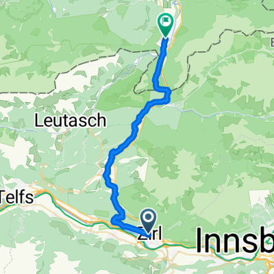
- Alpencross Mai 2010 Zirl - Seefeld in Tirol
- Distance
- 10.1 km
- Ascent
- 652 m
- Descent
- 106 m
- Location
- Unterperfuss, Tyrol, Austria
- Starkenberger und Adolf Pichler Hütte
- Distance
- 68.2 km
- Ascent
- 2,111 m
- Descent
- 2,111 m
- Location
- Unterperfuss, Tyrol, Austria
- Rangger Koepfl
- Distance
- 21.9 km
- Ascent
- 1,508 m
- Descent
- 200 m
- Location
- Unterperfuss, Tyrol, Austria
Open it in the app