

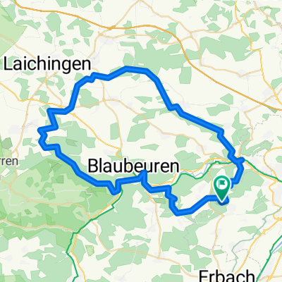
Zur Quelle der Weihung
A cycling route starting in Erbach, Baden-Württemberg, Germany.
Overview
About this route
Sollte man mal probieren
- -:--
- Duration
- 53.2 km
- Distance
- 269 m
- Ascent
- 267 m
- Descent
- ---
- Avg. speed
- ---
- Max. altitude
Route quality
Waytypes & surfaces along the route
Waytypes
Track
26.7 km
(50 %)
Quiet road
16.7 km
(31 %)
Surfaces
Paved
25.7 km
(48 %)
Unpaved
22.2 km
(42 %)
Asphalt
21.4 km
(40 %)
Gravel
15.1 km
(28 %)
Continue with Bikemap
Use, edit, or download this cycling route
You would like to ride Zur Quelle der Weihung or customize it for your own trip? Here is what you can do with this Bikemap route:
Free features
- Save this route as favorite or in collections
- Copy & plan your own version of this route
- Sync your route with Garmin or Wahoo
Premium features
Free trial for 3 days, or one-time payment. More about Bikemap Premium.
- Navigate this route on iOS & Android
- Export a GPX / KML file of this route
- Create your custom printout (try it for free)
- Download this route for offline navigation
Discover more Premium features.
Get Bikemap PremiumFrom our community
Other popular routes starting in Erbach
 ronde blaubeuren
- Distance
- 60.9 km
- Ascent
- 606 m
- Descent
- 606 m
- Location
- Erbach, Baden-Württemberg, Germany
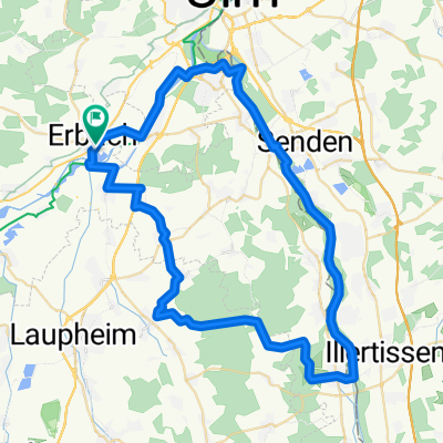
 Erbach - Illertissen - Iller entlang - Erbach
- Distance
- 61.5 km
- Ascent
- 213 m
- Descent
- 212 m
- Location
- Erbach, Baden-Württemberg, Germany
 Dellmensingen - Laupheim - Dietenheim - Dellmensingen
- Distance
- 74.4 km
- Ascent
- 364 m
- Descent
- 365 m
- Location
- Erbach, Baden-Württemberg, Germany
 MTB Feierabendrunde
- Distance
- 28.6 km
- Ascent
- 400 m
- Descent
- 397 m
- Location
- Erbach, Baden-Württemberg, Germany
 Dellmensingen Feierabend 30km
- Distance
- 31.2 km
- Ascent
- 54 m
- Descent
- 54 m
- Location
- Erbach, Baden-Württemberg, Germany
 Dellmensingen - Kleines Lautertal - Schillerstein
- Distance
- 55.9 km
- Ascent
- 660 m
- Descent
- 660 m
- Location
- Erbach, Baden-Württemberg, Germany
 Erbach - Illertissen - Iller entlang - Erbach
- Distance
- 61.5 km
- Ascent
- 185 m
- Descent
- 182 m
- Location
- Erbach, Baden-Württemberg, Germany
 Donautal 2009 4
- Distance
- 13 km
- Ascent
- 12 m
- Descent
- 14 m
- Location
- Erbach, Baden-Württemberg, Germany
Open it in the app