

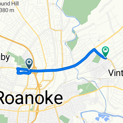
Roanoke/Peaks of Otter
A cycling route starting in Roanoke, Virginia, United States.
Overview
About this route
Partly hilly, flat from Roanoke to Buchanan. Steep 4 mile climb from Buchanan to Blue Ridge Parkway. Once on Parkway, you will go down hill for about 1 mile, at which you will again do more climbing. It will become flat near the end, and is a very nice finish to this ride. Build back those lost carbs in the lodge. Good food and cold drinks.
- -:--
- Duration
- 62.5 km
- Distance
- 838 m
- Ascent
- 387 m
- Descent
- ---
- Avg. speed
- ---
- Max. altitude
Route quality
Waytypes & surfaces along the route
Waytypes
Road
8.1 km
(13 %)
Quiet road
6.2 km
(10 %)
Surfaces
Paved
10 km
(16 %)
Asphalt
10 km
(16 %)
Undefined
52.5 km
(84 %)
Continue with Bikemap
Use, edit, or download this cycling route
You would like to ride Roanoke/Peaks of Otter or customize it for your own trip? Here is what you can do with this Bikemap route:
Free features
- Save this route as favorite or in collections
- Copy & plan your own version of this route
- Sync your route with Garmin or Wahoo
Premium features
Free trial for 3 days, or one-time payment. More about Bikemap Premium.
- Navigate this route on iOS & Android
- Export a GPX / KML file of this route
- Create your custom printout (try it for free)
- Download this route for offline navigation
Discover more Premium features.
Get Bikemap PremiumFrom our community
Other popular routes starting in Roanoke
 Lee Highway to Reserve Avenue Southwest
- Distance
- 7.4 km
- Ascent
- 48 m
- Descent
- 30 m
- Location
- Roanoke, Virginia, United States
 592 Bridge St SW, Roanoke to 592 Bridge St SW, Roanoke
- Distance
- 21.5 km
- Ascent
- 338 m
- Descent
- 336 m
- Location
- Roanoke, Virginia, United States
 Roanoke - Blue Ridge Parkway - Galax 166 km
- Distance
- 165.9 km
- Ascent
- 1,413 m
- Descent
- 976 m
- Location
- Roanoke, Virginia, United States
 Roanoke to Lake House
- Distance
- 50.8 km
- Ascent
- 689 m
- Descent
- 691 m
- Location
- Roanoke, Virginia, United States
 Bikeshare by RIDE Solutions
- Distance
- 34.6 km
- Ascent
- 112 m
- Descent
- 123 m
- Location
- Roanoke, Virginia, United States
 Roanoke to Christiansburg
- Distance
- 71.1 km
- Ascent
- 1,286 m
- Descent
- 935 m
- Location
- Roanoke, Virginia, United States
 Roanoke/Peaks of Otter
- Distance
- 62.5 km
- Ascent
- 838 m
- Descent
- 387 m
- Location
- Roanoke, Virginia, United States
 Recovered Route
- Distance
- 5.3 km
- Ascent
- 51 m
- Descent
- 39 m
- Location
- Roanoke, Virginia, United States
Open it in the app