

2º Etapa Clasica Collado Mediano Oropesa
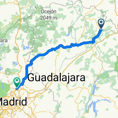
A cycling route starting in Siguenza, Castille-La Mancha, Spain.
Overview
About this route
Leg-breaking stage, not very long but not flat at all.
- -:--
- Duration
- 117.4 km
- Distance
- 1,021 m
- Ascent
- 793 m
- Descent
- ---
- Avg. speed
- ---
- Max. altitude
Route quality
Waytypes & surfaces along the route
Waytypes
Cycleway
44.6 km
(38 %)
Track
15.3 km
(13 %)
Surfaces
Paved
8.2 km
(7 %)
Unpaved
9.4 km
(8 %)
Asphalt
8.2 km
(7 %)
Ground
4.7 km
(4 %)
Continue with Bikemap
Use, edit, or download this cycling route
You would like to ride 2º Etapa Clasica Collado Mediano Oropesa or customize it for your own trip? Here is what you can do with this Bikemap route:
Free features
- Save this route as favorite or in collections
- Copy & plan your own version of this route
- Split it into stages to create a multi-day tour
- Sync your route with Garmin or Wahoo
Premium features
Free trial for 3 days, or one-time payment. More about Bikemap Premium.
- Navigate this route on iOS & Android
- Export a GPX / KML file of this route
- Create your custom printout (try it for free)
- Download this route for offline navigation
Discover more Premium features.
Get Bikemap PremiumFrom our community
Other popular routes starting in Siguenza
 Zum See
- Distance
- 54.6 km
- Ascent
- 750 m
- Descent
- 482 m
- Location
- Siguenza, Castille-La Mancha, Spain
 2009 9. Etappe Tour Vire - Sanse
- Distance
- 128.2 km
- Ascent
- 592 m
- Descent
- 937 m
- Location
- Siguenza, Castille-La Mancha, Spain
 Weg von der autobahn
- Distance
- 140.1 km
- Ascent
- 2,362 m
- Descent
- 2,542 m
- Location
- Siguenza, Castille-La Mancha, Spain
 Day 20
- Distance
- 100.6 km
- Ascent
- 834 m
- Descent
- 841 m
- Location
- Siguenza, Castille-La Mancha, Spain
 Tajo Celtibero
- Distance
- 227.9 km
- Ascent
- 1,497 m
- Descent
- 1,500 m
- Location
- Siguenza, Castille-La Mancha, Spain
 (8) Final Siguenza - La Villa de don Fadrique, 218km, 1020HM (Hotel)
- Distance
- 217.6 km
- Ascent
- 930 m
- Descent
- 1,248 m
- Location
- Siguenza, Castille-La Mancha, Spain
 Sigüenza - Valle del río Salado - Sigüenza
- Distance
- 50.5 km
- Ascent
- 513 m
- Descent
- 514 m
- Location
- Siguenza, Castille-La Mancha, Spain
 LOS DOS RIOS
- Distance
- 31.2 km
- Ascent
- 380 m
- Descent
- 382 m
- Location
- Siguenza, Castille-La Mancha, Spain
Open it in the app