
15km MTB Metzerlerchrütz&Downhill
A cycling route starting in Leymen, Grand Est, France.
Overview
About this route
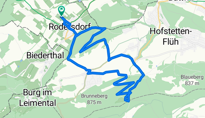
Metzerlerchrütz & downhill
- -:--
- Duration
- 15.3 km
- Distance
- 486 m
- Ascent
- 486 m
- Descent
- ---
- Avg. speed
- ---
- Max. altitude

Route quality
Waytypes & surfaces along the route
Waytypes
Track
7.7 km
(50 %)
Quiet road
2 km
(13 %)
Surfaces
Paved
5.2 km
(34 %)
Unpaved
6.9 km
(45 %)
Asphalt
4.8 km
(31 %)
Unpaved (undefined)
3.2 km
(21 %)
Continue with Bikemap
Use, edit, or download this cycling route
You would like to ride 15km MTB Metzerlerchrütz&Downhill or customize it for your own trip? Here is what you can do with this Bikemap route:
Free features
- Save this route as favorite or in collections
- Copy & plan your own version of this route
- Sync your route with Garmin or Wahoo
Premium features
Free trial for 3 days, or one-time payment. More about Bikemap Premium.
- Navigate this route on iOS & Android
- Export a GPX / KML file of this route
- Create your custom printout (try it for free)
- Download this route for offline navigation
Discover more Premium features.
Get Bikemap PremiumFrom our community
Other popular routes starting in Leymen
 15km MTB Metzerlerchrütz&Downhill
- Distance
- 15.3 km
- Ascent
- 486 m
- Descent
- 486 m
- Location
- Leymen, Grand Est, France
 69km Bike R'dorf-G'berg-Pt_Kohlberg-Grande Roche-Habschelle
- Distance
- 69.3 km
- Ascent
- 1,702 m
- Descent
- 1,702 m
- Location
- Leymen, Grand Est, France
 Süngau 39Km 430m
- Distance
- 39.2 km
- Ascent
- 445 m
- Descent
- 445 m
- Location
- Leymen, Grand Est, France
 85km Rennvelo - R'dorf-Gempen-Reigoldswil-Büsserach-Laufen-Aesch-Hofstetten-Metzerlen
- Distance
- 85.8 km
- Ascent
- 989 m
- Descent
- 989 m
- Location
- Leymen, Grand Est, France
 24km MTB Blauen-Kamm
- Distance
- 24.6 km
- Ascent
- 706 m
- Descent
- 706 m
- Location
- Leymen, Grand Est, France
 ZZ FRANCE Elsass Wolschwiller-Wolschwiller
- Distance
- 89.3 km
- Ascent
- 470 m
- Descent
- 470 m
- Location
- Leymen, Grand Est, France
 Rodersdorf - Pt Kohlberg - Lucelle - Rämel
- Distance
- 60.7 km
- Ascent
- 1,190 m
- Descent
- 1,190 m
- Location
- Leymen, Grand Est, France
 35km Elsass
- Distance
- 34.7 km
- Ascent
- 388 m
- Descent
- 386 m
- Location
- Leymen, Grand Est, France
Open it in the app