

Am Hochrhein
A cycling route starting in Kembs, Grand Est, France.
Overview
About this route
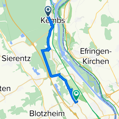
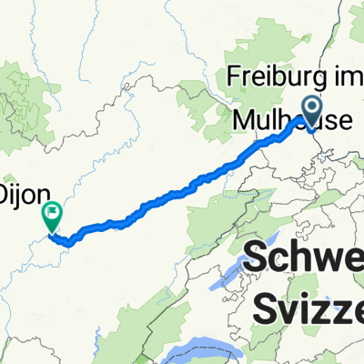
from Kemps along the Canal d'Huningue to Weil am Rhein, on the German side of the Rhine to Neuenburg, there over the bridge and via Ottmarsheim back to Kembs
- -:--
- Duration
- 81.8 km
- Distance
- 67 m
- Ascent
- 70 m
- Descent
- ---
- Avg. speed
- ---
- Max. altitude
Route highlights
Points of interest along the route
Point of interest after 40.4 km
Rast am Kurpark
Point of interest after 46.4 km
Bad im Rhein
Continue with Bikemap
Use, edit, or download this cycling route
You would like to ride Am Hochrhein or customize it for your own trip? Here is what you can do with this Bikemap route:
Free features
- Save this route as favorite or in collections
- Copy & plan your own version of this route
- Split it into stages to create a multi-day tour
- Sync your route with Garmin or Wahoo
Premium features
Free trial for 3 days, or one-time payment. More about Bikemap Premium.
- Navigate this route on iOS & Android
- Export a GPX / KML file of this route
- Create your custom printout (try it for free)
- Download this route for offline navigation
Discover more Premium features.
Get Bikemap PremiumFrom our community
Other popular routes starting in Kembs
 Eurovelo 6 Day 15
- Distance
- 77.9 km
- Ascent
- 260 m
- Descent
- 203 m
- Location
- Kembs, Grand Est, France
 De Rue des Mésanges 6, Kembs a Rue de la Pisciculture 1, Saint-Louis
- Distance
- 12.4 km
- Ascent
- 32 m
- Descent
- 21 m
- Location
- Kembs, Grand Est, France
 VCA CM Einzelzeitfahren Kembs Landau
- Distance
- 11.5 km
- Ascent
- 0 m
- Descent
- 12 m
- Location
- Kembs, Grand Est, France
 Am Hochrhein
- Distance
- 81.8 km
- Ascent
- 67 m
- Descent
- 70 m
- Location
- Kembs, Grand Est, France
 Clubmeisterschften VCA "Flachzeitfahren Niffer"
- Distance
- 20 km
- Ascent
- 4 m
- Descent
- 4 m
- Location
- Kembs, Grand Est, France
 Rue Principale 22, Niffer nach Impasse du Presbytère 2, Saint-Symphorien-sur-Saône
- Distance
- 229.8 km
- Ascent
- 1,647 m
- Descent
- 1,696 m
- Location
- Kembs, Grand Est, France
 PL - PdH
- Distance
- 2,256.5 km
- Ascent
- 5,061 m
- Descent
- 4,732 m
- Location
- Kembs, Grand Est, France
 sch222
- Distance
- 160.8 km
- Ascent
- 1,316 m
- Descent
- 1,117 m
- Location
- Kembs, Grand Est, France
Open it in the app