

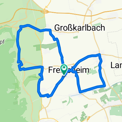
Lindemannsruh Tour über Leistadt
A cycling route starting in Freinsheim, Rhineland-Palatinate, Germany.
Overview
About this route
Zwischen Leistadt und Lindemannsruhe gehts recht steil hoch. Teilweise um die 13%. Nach Parkplatz Lindemannsruhe gehts locker weiter. Fährt mann von Freinsheim über Bissersheim nach hAltleiningen, ist die Steigung nicht so steil dafür ca. 12 Km lang.
- -:--
- Duration
- 33.5 km
- Distance
- 441 m
- Ascent
- 420 m
- Descent
- ---
- Avg. speed
- 488 m
- Max. altitude
Route quality
Waytypes & surfaces along the route
Waytypes
Road
13.6 km
(41 %)
Busy road
7.5 km
(22 %)
Surfaces
Paved
25.6 km
(77 %)
Unpaved
1.9 km
(6 %)
Asphalt
22.2 km
(66 %)
Ground
1.7 km
(5 %)
Continue with Bikemap
Use, edit, or download this cycling route
You would like to ride Lindemannsruh Tour über Leistadt or customize it for your own trip? Here is what you can do with this Bikemap route:
Free features
- Save this route as favorite or in collections
- Copy & plan your own version of this route
- Sync your route with Garmin or Wahoo
Premium features
Free trial for 3 days, or one-time payment. More about Bikemap Premium.
- Navigate this route on iOS & Android
- Export a GPX / KML file of this route
- Create your custom printout (try it for free)
- Download this route for offline navigation
Discover more Premium features.
Get Bikemap PremiumFrom our community
Other popular routes starting in Freinsheim
 Weinstraßenradrundweg durch die Urlaubsregion Freinsheim
- Distance
- 22.9 km
- Ascent
- 253 m
- Descent
- 253 m
- Location
- Freinsheim, Rhineland-Palatinate, Germany
 Weinstraßenradrundweg durch die Urlaubsregion Freinsheim - Weinstraßenradrundweg durch die Urlaubsregion Freinsheim
- Distance
- 22.7 km
- Ascent
- 260 m
- Descent
- 261 m
- Location
- Freinsheim, Rhineland-Palatinate, Germany
 Große Laufrunde
- Distance
- 19.7 km
- Ascent
- 260 m
- Descent
- 257 m
- Location
- Freinsheim, Rhineland-Palatinate, Germany
 Pfalztour Tag 1
- Distance
- 25.7 km
- Ascent
- 564 m
- Descent
- 500 m
- Location
- Freinsheim, Rhineland-Palatinate, Germany
 Oschelskopftour Deutsche Weinstraße
- Distance
- 31.5 km
- Ascent
- 281 m
- Descent
- 283 m
- Location
- Freinsheim, Rhineland-Palatinate, Germany
 Freins Nord
- Distance
- 53.6 km
- Ascent
- 196 m
- Descent
- 203 m
- Location
- Freinsheim, Rhineland-Palatinate, Germany
 Freinsheim - Kurpfalzpark
- Distance
- 18.4 km
- Ascent
- 231 m
- Descent
- 54 m
- Location
- Freinsheim, Rhineland-Palatinate, Germany
 Kleine Runde
- Distance
- 31.4 km
- Ascent
- 221 m
- Descent
- 193 m
- Location
- Freinsheim, Rhineland-Palatinate, Germany
Open it in the app