LGD-Pieszy - żółty szlak
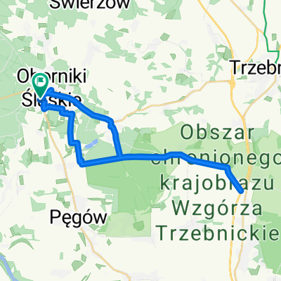
A cycling route starting in Oborniki Śląskie, Lower Silesian Voivodeship, Poland.
Overview
About this route
Pieszy szlak Uraz - Wrocław Widawa, możliwość przejazdu rowerem. Część odcinków wymaga korekty ze względu na zły stan utrzymania i zmiany w terenie.
- -:--
- Duration
- 18.4 km
- Distance
- 22 m
- Ascent
- 20 m
- Descent
- ---
- Avg. speed
- ---
- Max. altitude
Route quality
Waytypes & surfaces along the route
Waytypes
Track
8.3 km
(45 %)
Path
3.1 km
(17 %)
Surfaces
Paved
8.3 km
(45 %)
Unpaved
6.6 km
(36 %)
Asphalt
6.1 km
(33 %)
Gravel
3 km
(16 %)
Route highlights
Points of interest along the route
Point of interest after 3.8 km
Początek odcinka mocno zarośniętego. Ścieżka biegnąca koroną wału bardzo rzadko uczęszczana.
Point of interest after 5.7 km
Koniec odcinaka mocni zarośniętego trudnego do przebycia.
Point of interest after 11.7 km
Początek odcinka prowadzącego przez pole uprawne, dalej nasypem kolejowym. Brak drożności szlaku.
Point of interest after 12.3 km
Koniec niedrożnego odcinka szlaku.
Point of interest after 12.4 km
Początek odcinka szlaku prowadzący pod mostem drogowym na Widawie, nieczytelne oznaczenia, konieczność korekty.
Point of interest after 12.8 km
Koniec odcinka biegnącego pod mostem.
Continue with Bikemap
Use, edit, or download this cycling route
You would like to ride LGD-Pieszy - żółty szlak or customize it for your own trip? Here is what you can do with this Bikemap route:
Free features
- Save this route as favorite or in collections
- Copy & plan your own version of this route
- Sync your route with Garmin or Wahoo
Premium features
Free trial for 3 days, or one-time payment. More about Bikemap Premium.
- Navigate this route on iOS & Android
- Export a GPX / KML file of this route
- Create your custom printout (try it for free)
- Download this route for offline navigation
Discover more Premium features.
Get Bikemap PremiumFrom our community
Other popular routes starting in Oborniki Śląskie
 Wycieczka nr 2.
- Distance
- 10.3 km
- Ascent
- 294 m
- Descent
- 249 m
- Location
- Oborniki Śląskie, Lower Silesian Voivodeship, Poland
 Wycieczka nr 4.
- Distance
- 27 km
- Ascent
- 471 m
- Descent
- 508 m
- Location
- Oborniki Śląskie, Lower Silesian Voivodeship, Poland
 LGD-Pieszy - żółty szlak
- Distance
- 18.4 km
- Ascent
- 22 m
- Descent
- 20 m
- Location
- Oborniki Śląskie, Lower Silesian Voivodeship, Poland
 Trasa relaksacyjna
- Distance
- 26.4 km
- Ascent
- 255 m
- Descent
- 302 m
- Location
- Oborniki Śląskie, Lower Silesian Voivodeship, Poland
 drogą Stumilowego Lasu
- Distance
- 19.7 km
- Ascent
- 61 m
- Descent
- 60 m
- Location
- Oborniki Śląskie, Lower Silesian Voivodeship, Poland
 Wycieczka nr 5.
- Distance
- 10.3 km
- Ascent
- 212 m
- Descent
- 185 m
- Location
- Oborniki Śląskie, Lower Silesian Voivodeship, Poland
 Wycieczka nr 6.
- Distance
- 9.4 km
- Ascent
- 303 m
- Descent
- 293 m
- Location
- Oborniki Śląskie, Lower Silesian Voivodeship, Poland
 Pętelka przez Wilczyn i Uraz
- Distance
- 23.3 km
- Ascent
- 62 m
- Descent
- 62 m
- Location
- Oborniki Śląskie, Lower Silesian Voivodeship, Poland
Open it in the app


