

KTW 2014
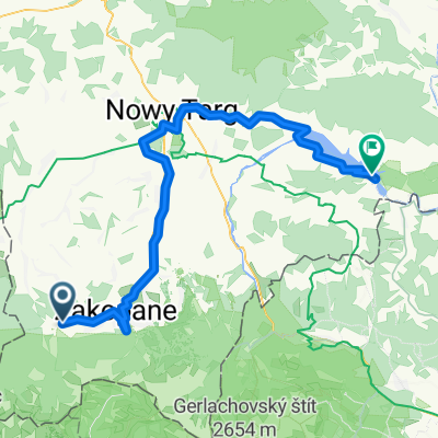
A cycling route starting in Kościelisko, Lesser Poland Voivodeship, Poland.
Overview
About this route
Departure of the versatile tourism course 2014
- -:--
- Duration
- 172.8 km
- Distance
- 1,625 m
- Ascent
- 1,775 m
- Descent
- ---
- Avg. speed
- ---
- Max. altitude

Route quality
Waytypes & surfaces along the route
Waytypes
Road
77.7 km
(45 %)
Track
39.7 km
(23 %)
Surfaces
Paved
93.3 km
(54 %)
Unpaved
38 km
(22 %)
Asphalt
89.8 km
(52 %)
Unpaved (undefined)
15.5 km
(9 %)
Continue with Bikemap
Use, edit, or download this cycling route
You would like to ride KTW 2014 or customize it for your own trip? Here is what you can do with this Bikemap route:
Free features
- Save this route as favorite or in collections
- Copy & plan your own version of this route
- Split it into stages to create a multi-day tour
- Sync your route with Garmin or Wahoo
Premium features
Free trial for 3 days, or one-time payment. More about Bikemap Premium.
- Navigate this route on iOS & Android
- Export a GPX / KML file of this route
- Create your custom printout (try it for free)
- Download this route for offline navigation
Discover more Premium features.
Get Bikemap PremiumFrom our community
Other popular routes starting in Kościelisko
 Smreczyński Staw
- Distance
- 7.1 km
- Ascent
- 416 m
- Descent
- 122 m
- Location
- Kościelisko, Lesser Poland Voivodeship, Poland
 D3 Velo Małopolska 2020
- Distance
- 130.9 km
- Ascent
- 551 m
- Descent
- 1,258 m
- Location
- Kościelisko, Lesser Poland Voivodeship, Poland
 Zakopane1
- Distance
- 19.2 km
- Ascent
- 398 m
- Descent
- 400 m
- Location
- Kościelisko, Lesser Poland Voivodeship, Poland
 Tatry Tour - Za5Team
- Distance
- 196.6 km
- Ascent
- 1,825 m
- Descent
- 1,829 m
- Location
- Kościelisko, Lesser Poland Voivodeship, Poland
 Chochołów - Euroregion Tatry Tour (I etap)
- Distance
- 48.9 km
- Ascent
- 497 m
- Descent
- 552 m
- Location
- Kościelisko, Lesser Poland Voivodeship, Poland
 Zakopane - Hel i trochę z powrotem 2013
- Distance
- 1,059.2 km
- Ascent
- 628 m
- Descent
- 1,404 m
- Location
- Kościelisko, Lesser Poland Voivodeship, Poland
 VII TRR, Etap 1 - Zakopane - Niedzica Zamek
- Distance
- 71.5 km
- Ascent
- 274 m
- Descent
- 672 m
- Location
- Kościelisko, Lesser Poland Voivodeship, Poland
 Single SRP 2015
- Distance
- 44.1 km
- Ascent
- 1,180 m
- Descent
- 1,180 m
- Location
- Kościelisko, Lesser Poland Voivodeship, Poland
Open it in the app