

DE LA MER AUX PREMIERS CONTREFORTS…
A cycling route starting in Saint-Raphaël, Provence-Alpes-Côte d'Azur Region, France.
Overview
About this route
<h3 style='padding: 0px; margin: 0px; font-size: 18px; line-height: 30px; font-weight: 400; font-family: Abel, 'Helvetica Neue', Helvetica, Arial, sans-serif; color: rgb(64, 52, 56);'>
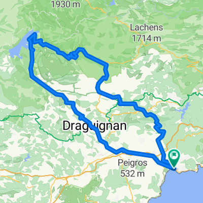
Blue Level, 70km, about 2h30</h3>
<p>
Starting from Saint-Raphaël, head toward Fréjus, then Saint-Aygulf. At the exit of Les Issambres, turn right to reach the Col du Bougnon (22km). Continue to Roquebrune sur Argens (33km) then at the crossroads of the 4 ways go straight under the highway bridge towards La Bouverie and then follow the direction to Bagnols en Foret. At the entrance of the village, turn right and follow the direction to Fréjus, Saint-Raphaël.</p>
Translated, show original (French)- -:--
- Duration
- 69.1 km
- Distance
- 486 m
- Ascent
- 486 m
- Descent
- ---
- Avg. speed
- ---
- Max. altitude
Route quality
Waytypes & surfaces along the route
Waytypes
Road
6.2 km
(9 %)
Quiet road
2.8 km
(4 %)
Surfaces
Paved
50.4 km
(73 %)
Asphalt
50.4 km
(73 %)
Undefined
18.7 km
(27 %)
Continue with Bikemap
Use, edit, or download this cycling route
You would like to ride DE LA MER AUX PREMIERS CONTREFORTS… or customize it for your own trip? Here is what you can do with this Bikemap route:
Free features
- Save this route as favorite or in collections
- Copy & plan your own version of this route
- Sync your route with Garmin or Wahoo
Premium features
Free trial for 3 days, or one-time payment. More about Bikemap Premium.
- Navigate this route on iOS & Android
- Export a GPX / KML file of this route
- Create your custom printout (try it for free)
- Download this route for offline navigation
Discover more Premium features.
Get Bikemap PremiumFrom our community
Other popular routes starting in Saint-Raphaël
 Tour du Mont Vinaigre
- Distance
- 17.4 km
- Ascent
- 436 m
- Descent
- 78 m
- Location
- Saint-Raphaël, Provence-Alpes-Côte d'Azur Region, France
 Esterelleküste und -berge
- Distance
- 64 km
- Ascent
- 584 m
- Descent
- 590 m
- Location
- Saint-Raphaël, Provence-Alpes-Côte d'Azur Region, France
 DE LA MER AUX PREMIERS CONTREFORTS…
- Distance
- 69.1 km
- Ascent
- 486 m
- Descent
- 486 m
- Location
- Saint-Raphaël, Provence-Alpes-Côte d'Azur Region, France
 Von Boulouris über Tanneron über die Corniche zurück
- Distance
- 84.8 km
- Ascent
- 2,479 m
- Descent
- 2,466 m
- Location
- Saint-Raphaël, Provence-Alpes-Côte d'Azur Region, France
 St. Raphael - Lac. St. Chroix
- Distance
- 194.3 km
- Ascent
- 2,128 m
- Descent
- 2,132 m
- Location
- Saint-Raphaël, Provence-Alpes-Côte d'Azur Region, France
 Boulouris - Cote de maures - zurück über Roquebrune
- Distance
- 109.2 km
- Ascent
- 622 m
- Descent
- 619 m
- Location
- Saint-Raphaël, Provence-Alpes-Côte d'Azur Region, France
 les caous
- Distance
- 16.1 km
- Ascent
- 479 m
- Descent
- 491 m
- Location
- Saint-Raphaël, Provence-Alpes-Côte d'Azur Region, France
 Esterel2
- Distance
- 35.8 km
- Ascent
- 550 m
- Descent
- 550 m
- Location
- Saint-Raphaël, Provence-Alpes-Côte d'Azur Region, France
Open it in the app