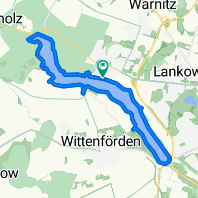
60km Richtung Bandenitz
A cycling route starting in Wittenförden, Mecklenburg-Vorpommern, Germany.
Overview
About this route
flache Feierabendrunde
(cloned from route 532186)
- -:--
- Duration
- 62 km
- Distance
- 95 m
- Ascent
- 92 m
- Descent
- ---
- Avg. speed
- ---
- Avg. speed
Route quality
Waytypes & surfaces along the route
Waytypes
Road
39 km
(63 %)
Quiet road
13.8 km
(22 %)
Surfaces
Paved
19.2 km
(31 %)
Unpaved
1.2 km
(2 %)
Asphalt
19 km
(31 %)
Gravel
1.2 km
(2 %)
Continue with Bikemap
Use, edit, or download this cycling route
You would like to ride 60km Richtung Bandenitz or customize it for your own trip? Here is what you can do with this Bikemap route:
Free features
- Save this route as favorite or in collections
- Copy & plan your own version of this route
- Sync your route with Garmin or Wahoo
Premium features
Free trial for 3 days, or one-time payment. More about Bikemap Premium.
- Navigate this route on iOS & Android
- Export a GPX / KML file of this route
- Create your custom printout (try it for free)
- Download this route for offline navigation
Discover more Premium features.
Get Bikemap PremiumFrom our community
Other popular routes starting in Wittenförden
- MTB - Neumühler See Natur pur
- Distance
- 15.2 km
- Ascent
- 110 m
- Descent
- 111 m
- Location
- Wittenförden, Mecklenburg-Vorpommern, Germany
- mdRzA 1.1.16
- Distance
- 22.7 km
- Ascent
- 75 m
- Descent
- 75 m
- Location
- Wittenförden, Mecklenburg-Vorpommern, Germany
- MTB - Neumühler See Natur pur CLONED FROM ROUTE 904585
- Distance
- 15.2 km
- Ascent
- 80 m
- Descent
- 81 m
- Location
- Wittenförden, Mecklenburg-Vorpommern, Germany
- Grambower Moor
- Distance
- 22.8 km
- Ascent
- 102 m
- Descent
- 97 m
- Location
- Wittenförden, Mecklenburg-Vorpommern, Germany
- Langer Nachmittag
- Distance
- 117.7 km
- Ascent
- 333 m
- Descent
- 334 m
- Location
- Wittenförden, Mecklenburg-Vorpommern, Germany
- Ost-bogen, Außensee und Weberin
- Distance
- 119.1 km
- Ascent
- 299 m
- Descent
- 298 m
- Location
- Wittenförden, Mecklenburg-Vorpommern, Germany
- MTB _ Aubachtal-GPS
- Distance
- 28.4 km
- Ascent
- 156 m
- Descent
- 157 m
- Location
- Wittenförden, Mecklenburg-Vorpommern, Germany
- Mühlen Eichsen und Innensee
- Distance
- 72.5 km
- Ascent
- 170 m
- Descent
- 170 m
- Location
- Wittenförden, Mecklenburg-Vorpommern, Germany
Open it in the app