

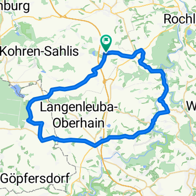
Narsdorf > Kohren-Sahlis>Geithain> Narsdorf
A cycling route starting in Narsdorf, Saxony, Germany.
Overview
About this route
23.05.2009:<br />Hinweg:<br />Narsdorf > Böttcherberg (Müllers Weg) > Lehmgrube Narsdorf > Kohren-Sahlis (Elisenhof) > Töpfermarkt (Kohren-Salis) > Waldweg Richtig Lindenvorwerk (Linda) > Rast in Gaststätte<br /><br />Rückweg:<br />Gaststätte (Linda) > Rund um den Lindenteich > Waldweg Richtung Kohrensalis > Richtung Walditz > Terpitz > Elisenhof > Syra > Geithain > Sommerhof (Geithain) > Narsdorf(über Wickershain)
(cloned from route 190523)
- -:--
- Duration
- 33.1 km
- Distance
- 219 m
- Ascent
- 216 m
- Descent
- ---
- Avg. speed
- ---
- Max. altitude
Route quality
Waytypes & surfaces along the route
Waytypes
Quiet road
14.2 km
(43 %)
Track
8.6 km
(26 %)
Surfaces
Paved
22.2 km
(67 %)
Unpaved
5 km
(15 %)
Asphalt
22.2 km
(67 %)
Gravel
3 km
(9 %)
Route highlights
Points of interest along the route
Point of interest after 0.7 km
Bötcherberg
Point of interest after 1.6 km
Lehmgrube
Point of interest after 2.9 km
Hegeteich / Hegewald
Point of interest after 7.7 km
Elisenhof
Point of interest after 11.9 km
Lindenteich
Point of interest after 16 km
Kohren-Sahlis
Point of interest after 24.3 km
Geithain
Continue with Bikemap
Use, edit, or download this cycling route
You would like to ride Narsdorf > Kohren-Sahlis>Geithain> Narsdorf or customize it for your own trip? Here is what you can do with this Bikemap route:
Free features
- Save this route as favorite or in collections
- Copy & plan your own version of this route
- Sync your route with Garmin or Wahoo
Premium features
Free trial for 3 days, or one-time payment. More about Bikemap Premium.
- Navigate this route on iOS & Android
- Export a GPX / KML file of this route
- Create your custom printout (try it for free)
- Download this route for offline navigation
Discover more Premium features.
Get Bikemap PremiumFrom our community
Other popular routes starting in Narsdorf
 11-01-22 Narsdorf Borna Windischleuba
- Distance
- 68.5 km
- Ascent
- 251 m
- Descent
- 248 m
- Location
- Narsdorf, Saxony, Germany
 Narsdorf > Kohren-Sahlis>Geithain> Narsdorf
- Distance
- 33.1 km
- Ascent
- 219 m
- Descent
- 216 m
- Location
- Narsdorf, Saxony, Germany
 Tour 09/2009 ESA
- Distance
- 65.4 km
- Ascent
- 480 m
- Descent
- 514 m
- Location
- Narsdorf, Saxony, Germany
 rund um talsperre kriebstein
- Distance
- 74.7 km
- Ascent
- 605 m
- Descent
- 608 m
- Location
- Narsdorf, Saxony, Germany
 Narsdorf Geithain (Hin und Rück)
- Distance
- 6 km
- Ascent
- 25 m
- Descent
- 42 m
- Location
- Narsdorf, Saxony, Germany
 rund um obergäfenhain
- Distance
- 40.7 km
- Ascent
- 279 m
- Descent
- 303 m
- Location
- Narsdorf, Saxony, Germany
 durchs muldental und königsfelder land
- Distance
- 67.1 km
- Ascent
- 661 m
- Descent
- 671 m
- Location
- Narsdorf, Saxony, Germany
 Ins Chemnitztal
- Distance
- 45.5 km
- Ascent
- 410 m
- Descent
- 408 m
- Location
- Narsdorf, Saxony, Germany
Open it in the app