

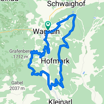
Gründeck-Runde
A cycling route starting in Wagrain, Salzburg, Austria.
Overview
About this route
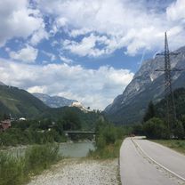
<span style="color: rgb(0, 0, 0); font-family: Verdana, Geneva, Arial, Helvetica, sans-serif; font-size: 10px; font-style: normal; font-variant: normal; font-weight: normal; letter-spacing: normal; line-height: normal; orphans: auto; text-align: start; text-indent: 0px; text-transform: none; white-space: normal; widows: auto; word-spacing: 0px; -webkit-text-stroke-width: 0px; display: inline !important; float: none;">Rund ums Hochgründeck als kurze Trainingsrunde. In Reitdorf am Zehenthof, einer der ältesten original erhaltenen Erbhöfe mit langer Familiengeschichte, links abbiegen über die Schachenbichl und Pichldörfer nach Eben und weiter ins Fritztal. Durch die Orte Hüttau (Kupferzeche – Schaubergwerk aus dem 13.!!! Jahrhundert) und Pöham bis zu Kreuzbergmaut. Durch Bischofshofen und hinter Mitterberghütten links über die Eisenbahn über die Dörfer nach St. Johann in unsere Bezirkshauptstadt mit dem Dom und weiter nach Wagrain.</span>
- -:--
- Duration
- 51.4 km
- Distance
- 478 m
- Ascent
- 477 m
- Descent
- ---
- Avg. speed
- ---
- Max. altitude

Route quality
Waytypes & surfaces along the route
Waytypes
Busy road
36.9 km
(72 %)
Quiet road
6.2 km
(12 %)
Surfaces
Paved
35.7 km
(69 %)
Asphalt
35.7 km
(69 %)
Undefined
15.8 km
(31 %)
Continue with Bikemap
Use, edit, or download this cycling route
You would like to ride Gründeck-Runde or customize it for your own trip? Here is what you can do with this Bikemap route:
Free features
- Save this route as favorite or in collections
- Copy & plan your own version of this route
- Sync your route with Garmin or Wahoo
Premium features
Free trial for 3 days, or one-time payment. More about Bikemap Premium.
- Navigate this route on iOS & Android
- Export a GPX / KML file of this route
- Create your custom printout (try it for free)
- Download this route for offline navigation
Discover more Premium features.
Get Bikemap PremiumFrom our community
Other popular routes starting in Wagrain
 Moderate Route in Werfen
- Distance
- 29.5 km
- Ascent
- 321 m
- Descent
- 679 m
- Location
- Wagrain, Salzburg, Austria
 Edelweiss hotel to Flachau to Edelweiss hotel
- Distance
- 25.8 km
- Ascent
- 2,615 m
- Descent
- 2,611 m
- Location
- Wagrain, Salzburg, Austria
 Mittelstation Flying Mozart – Bike Park Wagrain Runde
- Distance
- 10.2 km
- Ascent
- 419 m
- Descent
- 418 m
- Location
- Wagrain, Salzburg, Austria
 Grafenberg, Hachaualm
- Distance
- 19.9 km
- Ascent
- 977 m
- Descent
- 977 m
- Location
- Wagrain, Salzburg, Austria
 wagrain28km
- Distance
- 28.1 km
- Ascent
- 1,098 m
- Descent
- 1,098 m
- Location
- Wagrain, Salzburg, Austria
 Wagrain - Floitensberg - Lackenkapelle - Wagrain
- Distance
- 24.9 km
- Ascent
- 1,742 m
- Descent
- 1,753 m
- Location
- Wagrain, Salzburg, Austria
 Ö_Salzburg_Wagrain-Ahornkarkopf-Grießenkareck_LR-20.6km-1120hm
- Distance
- 20.6 km
- Ascent
- 1,131 m
- Descent
- 1,125 m
- Location
- Wagrain, Salzburg, Austria
 Gründeck-Runde
- Distance
- 51.4 km
- Ascent
- 478 m
- Descent
- 477 m
- Location
- Wagrain, Salzburg, Austria
Open it in the app